Home > Africa > Egypt > Maps
Jigsaw Puzzle : Maps / Suez Canal


![]()
Jigsaw Puzzles from Mary Evans Picture Library
Maps / Suez Canal
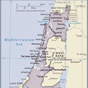
Map of the Suez Canal Date: 1908
Mary Evans Picture Library makes available wonderful images created for people to enjoy over the centuries
Media ID 7116949
© Mary Evans Picture Library 2015 - https://copyrighthub.org/s0/hub1/creation/maryevans/MaryEvansPictureID/10149996
Jigsaw Puzzle (252 Pieces)
Discover the rich history of global trade and exploration with our captivating Maps / Suez Canal jigsaw puzzle from Media Storehouse. This intriguing puzzle features an antique map of the Suez Canal, dated 1908, sourced from Mary Evans Prints Online. With intricate details and vivid colors, piecing together this puzzle will transport you on a journey through time as you connect the Red Sea to the Mediterranean. Ideal for puzzle enthusiasts, history buffs, or anyone in search of a challenging and rewarding activity. Bring the fascinating story of the Suez Canal into your home and enjoy the satisfaction of completing this beautiful and educational puzzle.
Made in the USA, 252-piece puzzles measure 11" x 14" (27.9 x 35.5 cm). Every puzzle is meticulously printed on glossy photo paper, which has a strong 1.33 mm thickness. Delivered in a black storage cardboard box, these puzzles are both stylish and practical. (Note: puzzles contain small parts and are not suitable for children under 3 years of age.)
Jigsaw Puzzles are an ideal gift for any occasion
Estimated Product Size is 28cm x 35.6cm (11" x 14")
These are individually made so all sizes are approximate
Artwork printed orientated as per the preview above, with portrait (vertical) orientation to match the source image.
FEATURES IN THESE COLLECTIONS
> Africa
> Egypt
> Related Images
EDITORS COMMENTS
1. Title: "Navigating the Past: A 1908 Map of the Suez Canal" This antique map print, dated 1908, showcases the Suez Canal in all its historical grandeur. The Suez Canal, an engineering marvel of the late 19th century, connects the Mediterranean Sea to the Red Sea, dividing Egypt and Africa, and significantly shortening the sea route between Europe and Asia. The map, produced by an unknown cartographer, meticulously details the canal's winding path, with intricate depictions of the various towns and cities along its banks. The map's rich detailing extends to the surrounding regions of Egypt and Africa, providing a comprehensive view of the geography and topography of the area. The Suez Canal, opened in 1869, revolutionized global trade and transportation by allowing ships to avoid the lengthy and treacherous journey around the Cape of Good Hope. This map, created just 39 years after the canal's inauguration, reflects the canal's burgeoning importance as a vital shipping route. The map's intricate design and historical significance make it an essential addition to any collection focused on cartography, maritime history, or the history of Egypt and Africa. This piece of history transports us back in time, allowing us to explore the Suez Canal as it was over a century ago. The map's antique charm, coupled with its historical significance, makes it a fascinating and educational addition to any home or office. Whether used as a conversation starter, a decorative piece, or a research tool, this map of the Suez Canal is sure to captivate and inspire. This map print is available for purchase from Mary Evans Prints Online, offering a unique and captivating glimpse into the past. With its rich history and intricate detailing, this map is a must-have for history buffs, cartography enthusiasts, and anyone with an appreciation for the world's fascinating past.
MADE IN THE USA
Safe Shipping with 30 Day Money Back Guarantee
FREE PERSONALISATION*
We are proud to offer a range of customisation features including Personalised Captions, Color Filters and Picture Zoom Tools
FREE COLORIZATION SERVICE
You can choose advanced AI Colorization for this picture at no extra charge!
SECURE PAYMENTS
We happily accept a wide range of payment options so you can pay for the things you need in the way that is most convenient for you
* Options may vary by product and licensing agreement. Zoomed Pictures can be adjusted in the Cart.