Home > Maps and Charts > Related Images
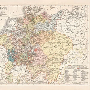
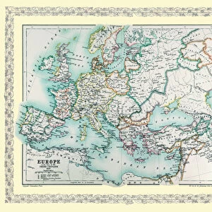
Map of Europe showing how it appeared in the year AD 1740

![]()
Wall Art and Photo Gifts from MapSeeker
Map of Europe showing how it appeared in the year AD 1740
EHIST010
Welcome to the Mapseeker Image library and enter an historic gateway to one of the largest on-line collections of Historic Maps, Nostalgic Views, Vista's and Panorama's from a World gone by.
Media ID 20348272
Europe Europe Map Map Of Europe
FEATURES IN THESE COLLECTIONS
> Maps and Charts
> Related Images
> MapSeeker
> Maps of Europe
> Old Maps of Europe and Small Islands of
EDITORS COMMENTS
This print showcases a historically significant artifact, the "Map of Europe showing how it appeared in the year AD 1740". A visual time capsule, this map offers a glimpse into the intricate political landscape and territorial boundaries that defined Europe during that era. With meticulous detail and expert cartography, this map presents an accurate representation of European countries as they stood more than two centuries ago. It allows us to trace the contours of nations long gone or transformed over time, providing valuable insights into geopolitical shifts and historical events. The vibrant colors used in this print bring life to each country's borders, highlighting their unique identities within a complex tapestry. From mighty empires like Prussia and Austria to smaller kingdoms such as Portugal and Sweden, every nation is meticulously labeled with its respective name. Beyond its aesthetic appeal, this map serves as a powerful educational tool for history enthusiasts and scholars alike. It invites exploration of past alliances forged through treaties or shattered by conflict. By examining Europe's political divisions in 1740, we gain deeper understanding of subsequent developments leading up to modern-day borders. Whether displayed in classrooms or personal collections dedicated to historical artifacts, this print from MapSeeker preserves an invaluable piece of European history. Its presence sparks curiosity about our shared past while reminding us how geography has shaped our present reality.
MADE IN THE USA
Safe Shipping with 30 Day Money Back Guarantee
FREE PERSONALISATION*
We are proud to offer a range of customisation features including Personalised Captions, Color Filters and Picture Zoom Tools
SECURE PAYMENTS
We happily accept a wide range of payment options so you can pay for the things you need in the way that is most convenient for you
* Options may vary by product and licensing agreement. Zoomed Pictures can be adjusted in the Cart.