Home > Arts > Artists > S > John Speed
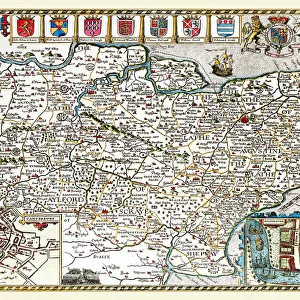
Old County Map of Worcestershire 1611 by John Speed

![]()
Wall Art and Photo Gifts from MapSeeker
Old County Map of Worcestershire 1611 by John Speed
A facimile of John Speeds historical map of Worcestershire originally published for the " Theatre of the Empire of Great Britain", an atlas to accompany " a history of Great Britain"
Welcome to the Mapseeker Image library and enter an historic gateway to one of the largest on-line collections of Historic Maps, Nostalgic Views, Vista's and Panorama's from a World gone by.
Media ID 20347743
© Mapseeker Publishing Ltd
County Map County Map Of England English County Map Historic Map John Speed Map Old County Map Old English County Map Speed Map Speede Map Worcestershire
FEATURES IN THESE COLLECTIONS
> Arts
> Artists
> S
> John Speed
> Europe
> United Kingdom
> England
> Maps
> Europe
> United Kingdom
> England
> Worcestershire
> Related Images
> Maps and Charts
> British Empire Maps
> Maps and Charts
> Early Maps
> Maps and Charts
> Related Images
> MapSeeker
> Maps from the British Isles
> England and Counties PORTFOLIO
EDITORS COMMENTS
This print showcases the "Old County Map of Worcestershire 1611" by John Speed, a renowned cartographer of his time. Originally published for the "Theatre of the Empire of Great Britain" an atlas accompanying a comprehensive history of Great Britain, this facsimile offers us a glimpse into Worcestershire's rich historical past. With its intricate details and exquisite craftsmanship, this old English county map takes us back to a bygone era. The map not only serves as a geographical representation but also provides valuable insights into the political and cultural landscape of Worcestershire during that period. John Speed's expertise in cartography is evident in every stroke and contour on this historic piece. The meticulous placement of towns, rivers, forests, and boundaries transports us to an England long ago. It allows us to trace the evolution of settlements over time and understand how they shaped the region we know today. As we explore this mesmerizing artwork, we are reminded that maps are more than just navigational tools; they hold stories within their lines and symbols. This particular map acts as a portal connecting us with our ancestors' footsteps while offering an opportunity to appreciate their world from centuries ago. Whether you're an avid historian or simply fascinated by geography, this old county map print is sure to captivate your imagination and spark curiosity about Worcestershire's intriguing past.
MADE IN THE USA
Safe Shipping with 30 Day Money Back Guarantee
FREE PERSONALISATION*
We are proud to offer a range of customisation features including Personalised Captions, Color Filters and Picture Zoom Tools
SECURE PAYMENTS
We happily accept a wide range of payment options so you can pay for the things you need in the way that is most convenient for you
* Options may vary by product and licensing agreement. Zoomed Pictures can be adjusted in the Cart.