Home > Oceania > Australia > Maps
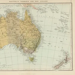
Photographic Print : Maps / Australia 1860S


![]()
Photo Prints from Mary Evans Picture Library
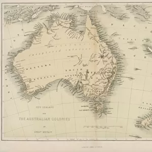
Maps / Australia 1860S
Map probably made soon after 1861
Mary Evans Picture Library makes available wonderful images created for people to enjoy over the centuries
Media ID 576482
© Mary Evans Picture Library 2015 - https://copyrighthub.org/s0/hub1/creation/maryevans/MaryEvansPictureID/10015337
14"x11" Photo Print
Discover the rich history of Australia with our exquisite collection of vintage maps from Mary Evans Picture Library. This particular print, titled "Maps / Australia 1860s," offers a fascinating glimpse into the territorial expanses of the land down under during an era of significant exploration and settlement. Embrace the captivating details of this intricately drawn map, which was likely produced soon after 1861. Each crease, line, and annotation adds to the allure of this historical artifact, transporting you back in time. Our high-quality photographic prints are meticulously crafted to bring the intricacies of historical maps to life. Each print is carefully produced using premium materials and state-of-the-art printing techniques to ensure vibrant colors and exceptional detail. Add this stunning piece to your collection and bring a touch of history into your home or office. The perfect addition for history enthusiasts, educators, or anyone with a passion for the past. Order now and let the intrigue of Australia's past unfold before your eyes.
Photo prints are produced on Kodak professional photo paper resulting in timeless and breath-taking prints which are also ideal for framing. The colors produced are rich and vivid, with accurate blacks and pristine whites, resulting in prints that are truly timeless and magnificent. Whether you're looking to display your prints in your home, office, or gallery, our range of photographic prints are sure to impress. Dimensions refers to the size of the paper in inches.
Our Photo Prints are in a large range of sizes and are printed on Archival Quality Paper for excellent colour reproduction and longevity. They are ideal for framing (our Framed Prints use these) at a reasonable cost. Alternatives include cheaper Poster Prints and higher quality Fine Art Paper, the choice of which is largely dependant on your budget.
Estimated Product Size is 35.5cm x 27.9cm (14" x 11")
These are individually made so all sizes are approximate
Artwork printed orientated as per the preview above, with landscape (horizontal) orientation to match the source image.
FEATURES IN THESE COLLECTIONS
> Maps and Charts
> Early Maps
EDITORS COMMENTS
This print of a map of Australia from the 1860s offers a fascinating glimpse into the historical geography of this vast and diverse continent. Created shortly after 1861, this meticulously detailed map provides valuable insight into the topography, settlements, and boundaries of Australia during this pivotal period in its history.
As we study this map, we can see how much has changed over the years in terms of exploration, colonization, and development. The intricate lines and labels on the map tell stories of expeditions, discoveries, and territorial disputes that have shaped Australia's landscape and identity.
From the rugged coastlines to the sprawling interior regions, every inch of land is carefully documented on this map. It serves as a reminder of the rich heritage and complex history that defines Australia as a nation.
Whether you are a history buff or simply curious about how our world has evolved over time, this vintage map is sure to spark your imagination and ignite your sense of wonder. Let yourself be transported back in time to an era when cartographers painstakingly charted unknown territories with nothing but pen and paper.
Discover Australia through new eyes with this remarkable print from Mary Evans Picture Library - a true treasure trove for anyone interested in exploring the past through maps.
MADE IN THE USA
Safe Shipping with 30 Day Money Back Guarantee
FREE PERSONALISATION*
We are proud to offer a range of customisation features including Personalised Captions, Color Filters and Picture Zoom Tools
SECURE PAYMENTS
We happily accept a wide range of payment options so you can pay for the things you need in the way that is most convenient for you
* Options may vary by product and licensing agreement. Zoomed Pictures can be adjusted in the Cart.