Home > Asia > Japan > Maps
Canvas Print : Maps / Americas 1540


![]()
Canvas Prints from Mary Evans Picture Library
Maps / Americas 1540
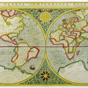
Map showing the discoveries by explorers during the first half-century after Columbus : note the confusion of India, Japan (Zipangri) and China (Cathay), & the Hesperides
Mary Evans Picture Library makes available wonderful images created for people to enjoy over the centuries
Media ID 582445
© Mary Evans Picture Library 2015 - https://copyrighthub.org/s0/hub1/creation/maryevans/MaryEvansPictureID/10029704
1540 Cathay Columbus Confusion Discoveries Explorers Half Hesperides Maps Note
20"x16" (51x41cm) Canvas Print
Discover the captivating history of the New World with our exquisite Canvas Prints from Media Storehouse, featuring the intriguing map "Maps / Americas 1540" by Mary Evans Picture Library. This fascinating map, sourced from Mary Evans Prints Online, offers a glimpse into the early explorations of the Americas during the first half-century after Columbus. Marvel at the confusion of India, Japan (Zipangri), and China (Cathay) as they were understood at the time. Delve into the mysteries of the Hesperides and the unexplored territories of the New World. Each detail on this map is brought to life with the rich textures and vibrant colors of our premium Canvas Prints. Bring history into your home or office with this beautifully detailed and historically significant piece of art. Our Canvas Prints are not only visually appealing but also long-lasting and easy to hang. Transport yourself back in time and add a touch of history to your space with Media Storehouse's "Maps / Americas 1540" Canvas Print.
Delivered stretched and ready to hang our premium quality canvas prints are made from a polyester/cotton blend canvas and stretched over a 1.25" (32mm) kiln dried knot free wood stretcher bar. Packaged in a plastic bag and secured to a cardboard insert for safe transit.
Canvas Prints add colour, depth and texture to any space. Professionally Stretched Canvas over a hidden Wooden Box Frame and Ready to Hang
Estimated Product Size is 50.8cm x 40.6cm (20" x 16")
These are individually made so all sizes are approximate
Artwork printed orientated as per the preview above, with landscape (horizontal) orientation to match the source image.
FEATURES IN THESE COLLECTIONS
> Asia
> India
> Related Images
> Asia
> Japan
> Related Images
> Maps and Charts
> Early Maps
> Maps and Charts
> India
> Mary Evans Prints Online
> Maps
EDITORS COMMENTS
This fascinating print from Mary Evans Picture Library showcases a map of the Americas from 1540, highlighting the discoveries made by explorers in the first half-century after Columbus. The map is not only historically significant but also visually captivating, with intricate details that reveal the confusion and misconceptions of the time.
One notable aspect of this map is the mix-up of various countries and regions - India, Japan (referred to as Zipangri), and China (known as Cathay) are all depicted in close proximity, showcasing how limited geographical knowledge was during this period. The inclusion of Hesperides adds an element of mystery and intrigue to the map, hinting at mythical lands or unexplored territories.
Overall, this print offers a glimpse into the past and serves as a reminder of how far we have come in terms of cartography and exploration. It is a testament to the bravery and curiosity of early explorers who ventured into unknown waters in search of new lands and opportunities.
Whether you are a history buff or simply appreciate beautiful artwork, this print is sure to spark your imagination and transport you back in time to an era where maps were filled with wonder and possibility.
MADE IN THE USA
Safe Shipping with 30 Day Money Back Guarantee
FREE PERSONALISATION*
We are proud to offer a range of customisation features including Personalised Captions, Color Filters and Picture Zoom Tools
SECURE PAYMENTS
We happily accept a wide range of payment options so you can pay for the things you need in the way that is most convenient for you
* Options may vary by product and licensing agreement. Zoomed Pictures can be adjusted in the Cart.