Home > Maps and Charts > World
Jigsaw Puzzle : MAPS / WORLD / 1894


![]()
Jigsaw Puzzles from Mary Evans Picture Library
MAPS / WORLD / 1894
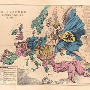
World map showing the European colonies
Mary Evans Picture Library makes available wonderful images created for people to enjoy over the centuries
Media ID 592844
© Mary Evans Picture Library 2015 - https://copyrighthub.org/s0/hub1/creation/maryevans/MaryEvansPictureID/10042277
Jigsaw Puzzle (252 Pieces)
Discover the rich history of global exploration with our captivating "MAPS / WORLD / 1894" jigsaw puzzle from the Media Storehouse collection, brought to you by Mary Evans Picture Library from Mary Evans Prints Online. This intriguing puzzle features an antique world map, showcasing the European colonies as they existed in 1894. Immerse yourself in a challenging and educational experience as you piece together this fascinating piece of cartographic history. The intricate details and vibrant colors will transport you back in time, making this puzzle a must-have for history buffs, puzzle enthusiasts, and anyone seeking a captivating mental adventure.
Made in the USA, 252-piece puzzles measure 11" x 14" (27.9 x 35.5 cm). Every puzzle is meticulously printed on glossy photo paper, which has a strong 1.33 mm thickness. Delivered in a black storage cardboard box, these puzzles are both stylish and practical. (Note: puzzles contain small parts and are not suitable for children under 3 years of age.)
Jigsaw Puzzles are an ideal gift for any occasion
Estimated Product Size is 35.6cm x 28cm (14" x 11")
These are individually made so all sizes are approximate
Artwork printed orientated as per the preview above, with landscape (horizontal) orientation to match the source image.
FEATURES IN THESE COLLECTIONS
> Maps and Charts
> Early Maps
> Maps and Charts
> World
EDITORS COMMENTS
This print from Mary Evans Picture Library showcases a historical world map dating back to 1894. The intricate details of this map provide a fascinating glimpse into the European colonies of that era, offering a snapshot of global history at the time.
As you study the map, you can see how European powers had established their presence and influence across various regions around the world. From Africa to Asia to the Americas, each colony is clearly marked, illustrating the extent of European imperialism during this period.
The colors and typography used in this map add to its charm and authenticity, making it a valuable piece for history enthusiasts and collectors alike. It serves as a reminder of how borders have shifted over time and how colonialism has shaped our modern world.
Whether displayed in a home library or office space, this vintage map is sure to spark conversations and inspire curiosity about past civilizations and geopolitical dynamics. It's not just a decorative piece but also an educational tool that invites viewers to explore different cultures and histories through cartography.
Overall, this print is more than just a visual representation of geographical locations; it's a window into the past that encourages us to reflect on our shared human experience throughout centuries.
MADE IN THE USA
Safe Shipping with 30 Day Money Back Guarantee
FREE PERSONALISATION*
We are proud to offer a range of customisation features including Personalised Captions, Color Filters and Picture Zoom Tools
SECURE PAYMENTS
We happily accept a wide range of payment options so you can pay for the things you need in the way that is most convenient for you
* Options may vary by product and licensing agreement. Zoomed Pictures can be adjusted in the Cart.