Home > Oceania > New Zealand > Maps
Jigsaw Puzzle : Maps / Australia / New Zea


![]()
Jigsaw Puzzles from Mary Evans Picture Library
Maps / Australia / New Zea
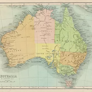
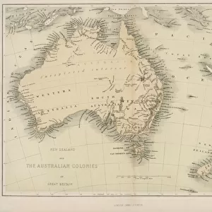
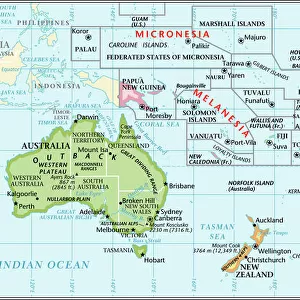
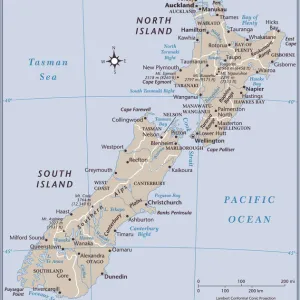
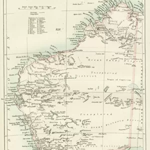
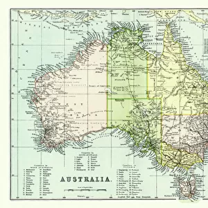
Map showing Australia, Tasmania, New Zealand and neighbouring islands
Mary Evans Picture Library makes available wonderful images created for people to enjoy over the centuries
Media ID 576483
© Mary Evans Picture Library 2015 - https://copyrighthub.org/s0/hub1/creation/maryevans/MaryEvansPictureID/10015338
Maps Neighbouring Tasmania Zealand
Jigsaw Puzzle (252 Pieces)
Discover the beauty and complexity of the South Pacific with our latest addition to the Media Storehouse Jigsaw Puzzles collection. This captivating puzzle, brought to you by Mary Evans Picture Library from Mary Evans Prints Online, showcases an intricate map of Australia, Tasmania, New Zealand, and their neighboring islands. Immerse yourself in the exploration of this vibrant region, as you piece together the intricate details of this jigsaw puzzle. Perfect for puzzle enthusiasts and geography lovers alike, this puzzle is a must-have for anyone seeking a challenging and rewarding experience. Let the adventure begin!
Made in the USA, 252-piece puzzles measure 11" x 14" (27.9 x 35.5 cm). Every puzzle is meticulously printed on glossy photo paper, which has a strong 1.33 mm thickness. Delivered in a black storage cardboard box, these puzzles are both stylish and practical. (Note: puzzles contain small parts and are not suitable for children under 3 years of age.)
Jigsaw Puzzles are an ideal gift for any occasion
Estimated Product Size is 35.6cm x 28cm (14" x 11")
These are individually made so all sizes are approximate
Artwork printed orientated as per the preview above, with landscape (horizontal) orientation to match the source image.
FEATURES IN THESE COLLECTIONS
> Maps and Charts
> Early Maps
> Mary Evans Prints Online
> Maps
> Oceania
> New Zealand
> Maps
> Oceania
> New Zealand
> Related Images
EDITORS COMMENTS
1. Title: "Exploring the Pacific: A Historical Map Showcasing Australia, New Zealand, and Neighbouring Islands (circa 1890)" This historical map print, sourced from Mary Evans Picture Library, offers a glimpse into the geographical knowledge of the late 19th century. The map meticulously outlines the vast expanse of the Pacific Ocean, with a particular focus on the regions of Australia, Tasmania, New Zealand, and their neighbouring islands. The map, produced circa 1890, showcases the intricate details of the Australian continent, including its various territories and islands, such as Tasmania. The map also highlights the unique cartographic representation of New Zealand, with its distinctive shapes and labels. The neighbouring islands, including Fiji, Papua New Guinea, and the Solomon Islands, are also depicted, offering a broader perspective of the Pacific region during this era. The map's historical significance lies in its ability to provide insight into the geographical understanding of the Pacific during a time when European exploration and colonization were at their peak. The intricate detail and accuracy of the map are a testament to the cartographic skills of the time. The use of vivid colours and clear labeling makes it an engaging and informative piece for anyone interested in the history of Australia, New Zealand, and the wider Pacific region. Whether used as a decorative piece in a home or office, or as a teaching tool for students, this historical map print is a captivating reminder of the rich history and cultural connections that bind the countries of the Pacific together. In conclusion, this map print from Mary Evans Picture Library is a must-have for anyone with a passion for history, geography, or the Pacific region. Its historical significance, intricate detail, and captivating design make it a valuable addition to any collection.
MADE IN THE USA
Safe Shipping with 30 Day Money Back Guarantee
FREE PERSONALISATION*
We are proud to offer a range of customisation features including Personalised Captions, Color Filters and Picture Zoom Tools
SECURE PAYMENTS
We happily accept a wide range of payment options so you can pay for the things you need in the way that is most convenient for you
* Options may vary by product and licensing agreement. Zoomed Pictures can be adjusted in the Cart.