Home > South America > Brazil > Maps
Framed Print : Map /s America / Brazil 18C


![]()
Framed Photos from Mary Evans Picture Library
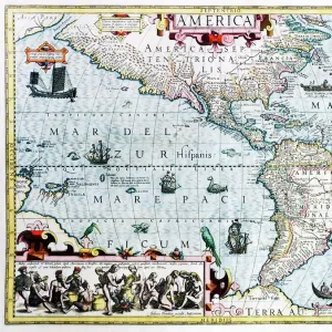
Map /s America / Brazil 18C
Map of Brazil, with coastal towns well documented
Mary Evans Picture Library makes available wonderful images created for people to enjoy over the centuries
Media ID 608861
© Mary Evans Picture Library 2015 - https://copyrighthub.org/s0/hub1/creation/maryevans/MaryEvansPictureID/10114196
1704 Brazil Maps Towns Documented
22"x18" Modern Frame
Introducing the stunning "Map /s America / Brazil 18C" from our Media Storehouse Framed Prints collection, exclusive to Mary Evans Picture Library. This beautifully detailed and intricately designed map takes you back in time to the 18th century, showcasing an extensive and accurate depiction of the coastline of Brazil. Each town, bay, and inlet is meticulously documented, making this a must-have for history enthusiasts and cartography aficionados. Our high-quality framed prints are made to order with archival-quality materials, ensuring that the vibrant colors and fine details of this historical map are preserved for generations to come. Add a touch of history and sophistication to your home or office with this exquisite piece from the Media Storehouse Framed Prints collection.
20x16 Print in an MDF Wooden Frame with 180 gsm Satin Finish Paper. Glazed using shatter proof thin plexiglass. Frame thickness is 1 inch and depth 0.75 inch. Fluted cardboard backing held with clips. Supplied ready to hang with sawtooth hanger and rubber bumpers. Spot clean with a damp cloth. Packaged foam wrapped in a card.
Contemporary Framed and Mounted Prints - Professionally Made and Ready to Hang
Estimated Image Size (if not cropped) is 50.8cm x 45.7cm (20" x 18")
Estimated Product Size is 55.9cm x 45.7cm (22" x 18")
These are individually made so all sizes are approximate
Artwork printed orientated as per the preview above, with landscape (horizontal) orientation to match the source image.
FEATURES IN THESE COLLECTIONS
> Maps and Charts
> Early Maps
> South America
> Brazil
> Maps
> South America
> Brazil
> Related Images
EDITORS COMMENTS
This stunning print captures a piece of history with its depiction of a map of Brazil from the 18th century. The intricate details and coastal towns well documented on this map provide a fascinating glimpse into the past, showcasing the rich historical significance of this South American country.
Dating back to 1704, this map offers a unique perspective on Brazil's geography and settlement patterns during that time period. Each town is meticulously labeled, giving viewers insight into the bustling communities that existed along the coast centuries ago.
The artistic quality of this map is truly remarkable, with delicate lines and ornate typography adding to its overall charm. It serves as a reminder of the importance of cartography in documenting our world's evolution over time.
Whether you have an interest in Brazilian history, maps, or simply appreciate fine artistry, this print from Mary Evans Picture Library is sure to captivate your imagination. Display it proudly in your home or office as a conversation starter and a beautiful homage to the past.
MADE IN THE USA
Safe Shipping with 30 Day Money Back Guarantee
FREE PERSONALISATION*
We are proud to offer a range of customisation features including Personalised Captions, Color Filters and Picture Zoom Tools
SECURE PAYMENTS
We happily accept a wide range of payment options so you can pay for the things you need in the way that is most convenient for you
* Options may vary by product and licensing agreement. Zoomed Pictures can be adjusted in the Cart.