Home > Europe > Netherlands > Maps
Map / Netherlands / Amsterda

![]()
Wall Art and Photo Gifts from Mary Evans Picture Library
Map / Netherlands / Amsterda
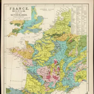
Map of Amsterdam
Mary Evans Picture Library makes available wonderful images created for people to enjoy over the centuries
Media ID 608828
© Mary Evans Picture Library 2015 - https://copyrighthub.org/s0/hub1/creation/maryevans/MaryEvansPictureID/10114112
FEATURES IN THESE COLLECTIONS
> Europe
> Netherlands
> Amsterdam
> Europe
> Netherlands
> Maps
> Maps and Charts
> Early Maps
> Maps and Charts
> Netherlands
EDITORS COMMENTS
Step back in time with this historical map of Amsterdam, the jewel of the Netherlands, as it appeared around the turn of the 17th century. This intricately detailed map, titled "Amsterdam in Holland," is an exquisite example of Dutch cartography from the past. Dated circa 1600, it offers a fascinating glimpse into the city's rich history and the bustling commercial activity that made Amsterdam one of Europe's most influential centers during the Dutch Golden Age. The map, held in the esteemed collections of Mary Evans Picture Library, reveals the layout of Amsterdam's streets and canals as they were in the early 17th century. The city's iconic grid pattern is evident, with the Singel and Herengracht canals forming the outer boundary, and the Damrak leading to the Dam Square at the heart of the city. The map also highlights various key landmarks, such as the City Hall, the Royal Palace, and the Bourse or Stock Exchange. Amsterdam's strategic location at the mouth of the River Amstel made it an essential trading hub, and this map reflects the city's thriving commerce. Ships are depicted anchored in the harbor, and various trade routes are indicated, connecting Amsterdam to cities throughout Europe and beyond. The map's meticulous annotations, including the names of streets, canals, and important buildings, provide valuable insights into the city's history and its role in the broader European context. This beautifully preserved map is not only a testament to the cartographic skills of its creator but also a captivating window into the past. As you explore the intricate details of this historical map of Amsterdam, you'll be transported back to a time when the city was at the forefront of European trade and culture.
MADE IN THE USA
Safe Shipping with 30 Day Money Back Guarantee
FREE PERSONALISATION*
We are proud to offer a range of customisation features including Personalised Captions, Color Filters and Picture Zoom Tools
SECURE PAYMENTS
We happily accept a wide range of payment options so you can pay for the things you need in the way that is most convenient for you
* Options may vary by product and licensing agreement. Zoomed Pictures can be adjusted in the Cart.