Home > Europe > France > Maps
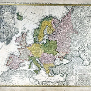
Photographic Print : Map / Europe / Germany 1880S


![]()
Photo Prints from Mary Evans Picture Library
Map / Europe / Germany 1880S
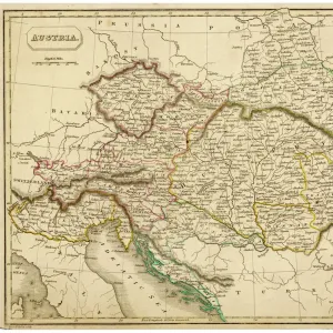
Map of the German Empire (southern part) after the war with France, including Alsace and Lorraine
Mary Evans Picture Library makes available wonderful images created for people to enjoy over the centuries
Media ID 4357663
© Mary Evans Picture Library 2015 - https://copyrighthub.org/s0/hub1/creation/maryevans/MaryEvansPictureID/10114038
Alsace Including Lorraine Maps Southern
14"x11" Photo Print
Discover history through the lens with our exquisite selection of Media Storehouse Photographic Prints. This captivating image, sourced from Mary Evans Prints Online, transports you back in time to the late 1800s with a detailed map of the German Empire (southern part). Witness the historical significance of the region, including the annexation of Alsace and Lorraine after the war with France. Each print is meticulously produced to bring out the intricate details, making it a stunning addition to your home or office decor. Order now and let this print be a conversation starter, igniting curiosity and knowledge about the past.
Photo prints are produced on Kodak professional photo paper resulting in timeless and breath-taking prints which are also ideal for framing. The colors produced are rich and vivid, with accurate blacks and pristine whites, resulting in prints that are truly timeless and magnificent. Whether you're looking to display your prints in your home, office, or gallery, our range of photographic prints are sure to impress. Dimensions refers to the size of the paper in inches.
Our Photo Prints are in a large range of sizes and are printed on Archival Quality Paper for excellent colour reproduction and longevity. They are ideal for framing (our Framed Prints use these) at a reasonable cost. Alternatives include cheaper Poster Prints and higher quality Fine Art Paper, the choice of which is largely dependant on your budget.
Estimated Product Size is 35.5cm x 27.9cm (14" x 11")
These are individually made so all sizes are approximate
Artwork printed orientated as per the preview above, with landscape (horizontal) or portrait (vertical) orientation to match the source image.
FEATURES IN THESE COLLECTIONS
> Maps and Charts
> Early Maps
EDITORS COMMENTS
This vintage map print showcases the southern part of the German Empire in the 1880s, following the war with France. The detailed cartography includes regions such as Alsace and Lorraine, which were hotly contested territories during this period of history. The map provides a fascinating glimpse into Europe's political landscape at a time when borders were constantly shifting.
The intricate design and historical significance of this map make it a captivating piece for any history enthusiast or collector. It serves as a reminder of the complex relationships between nations and the ever-changing nature of geopolitics.
With its muted color palette and intricate details, this map exudes an old-world charm that is sure to add character to any space. Whether displayed in a study, library, or living room, this print is bound to spark conversations about European history and the legacy of past conflicts.
Overall, this map print from Mary Evans Prints Online is not just a decorative piece but also a valuable historical artifact that offers insight into Germany's territorial expansion and geopolitical ambitions in the late 19th century. A must-have for anyone interested in European history or cartography.
MADE IN THE USA
Safe Shipping with 30 Day Money Back Guarantee
FREE PERSONALISATION*
We are proud to offer a range of customisation features including Personalised Captions, Color Filters and Picture Zoom Tools
SECURE PAYMENTS
We happily accept a wide range of payment options so you can pay for the things you need in the way that is most convenient for you
* Options may vary by product and licensing agreement. Zoomed Pictures can be adjusted in the Cart.