Home > Europe > United Kingdom > Wales > Maps
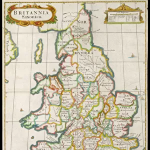
Canvas Print : Map / Britain / Saxon Period


![]()
Canvas Prints from Mary Evans Picture Library
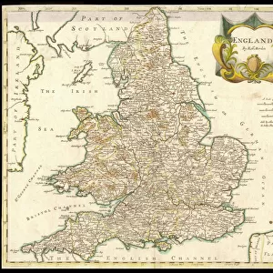
Map / Britain / Saxon Period
Map of England and Wales showing kingdoms of Saxon heptarchy
Mary Evans Picture Library makes available wonderful images created for people to enjoy over the centuries
Media ID 579234
© Mary Evans Picture Library 2015 - https://copyrighthub.org/s0/hub1/creation/maryevans/MaryEvansPictureID/10021575
20"x16" (51x41cm) Canvas Print
Introducing the captivating "Map / Britain / Saxon Period" Canvas Print from the Media Storehouse collection, brought to you by Mary Evans Picture Library from Mary Evans Prints Online. This exquisite piece transports you back in time to the Saxon period with an intricately detailed map of England and Wales, highlighting the kingdoms of the Saxon Heptarchy. Each line and border is meticulously rendered, inviting you to explore the rich history of this era. The high-quality canvas print is a stunning addition to any room, elevating the decor with its vintage charm and historical significance. Bring history to life in your home with this beautiful and authentic representation of the past.
Delivered stretched and ready to hang our premium quality canvas prints are made from a polyester/cotton blend canvas and stretched over a 1.25" (32mm) kiln dried knot free wood stretcher bar. Packaged in a plastic bag and secured to a cardboard insert for safe transit.
Canvas Prints add colour, depth and texture to any space. Professionally Stretched Canvas over a hidden Wooden Box Frame and Ready to Hang
Estimated Product Size is 40.6cm x 50.8cm (16" x 20")
These are individually made so all sizes are approximate
Artwork printed orientated as per the preview above, with portrait (vertical) orientation to match the source image.
FEATURES IN THESE COLLECTIONS
> Europe
> United Kingdom
> England
> Maps
> Europe
> United Kingdom
> Wales
> Maps
> Europe
> United Kingdom
> Wales
> Posters
> Europe
> United Kingdom
> Wales
> Related Images
> Maps and Charts
> Early Maps
> Maps and Charts
> Wales
> Mary Evans Prints Online
> Maps
EDITORS COMMENTS
This stunning print captures a detailed map of Britain during the Saxon period, showcasing the intricate kingdoms of the heptarchy. Dating back to the 6th and 8th centuries, this historical map provides a fascinating glimpse into England and Wales during this pivotal time in history.
The divisions of power among the various Saxon kingdoms are clearly delineated on this map, offering insight into the political landscape of early medieval Britain. From Mercia to Wessex, each kingdom played a crucial role in shaping the future of England as we know it today.
As you study this image, you can almost imagine yourself traveling back in time to witness firsthand the struggles and triumphs of these ancient peoples. The intricate details and vibrant colors bring this piece of history to life, allowing us to connect with our past in a tangible way.
Whether you're a history buff or simply appreciate beautiful artwork, this map is sure to captivate your imagination and spark your curiosity about Britain's rich heritage. Display it proudly in your home or office as a conversation starter and reminder of how far we've come as a nation.
MADE IN THE USA
Safe Shipping with 30 Day Money Back Guarantee
FREE PERSONALISATION*
We are proud to offer a range of customisation features including Personalised Captions, Color Filters and Picture Zoom Tools
SECURE PAYMENTS
We happily accept a wide range of payment options so you can pay for the things you need in the way that is most convenient for you
* Options may vary by product and licensing agreement. Zoomed Pictures can be adjusted in the Cart.