Home > Maps and Charts > Americas
Framed Print : Map / Atlantic Ocean


![]()
Framed Photos from Mary Evans Picture Library
Map / Atlantic Ocean
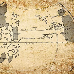
Map of the Atlantic Ocean according to Toscanelli, before the discovery of America
Mary Evans Picture Library makes available wonderful images created for people to enjoy over the centuries
Media ID 608852
© Mary Evans Picture Library 2015 - https://copyrighthub.org/s0/hub1/creation/maryevans/MaryEvansPictureID/10114182
22"x18" Modern Frame
Introducing the captivating "Map / Atlantic Ocean" framed print from the Media Storehouse collection, exclusively sourced from Mary Evans Picture Library's extensive archive. This stunning piece showcases an intriguing map of the Atlantic Ocean, as depicted by the renowned cartographer Ptolemy's disciple, Toscanelli. Created before the discovery of America, this captivating map transports you back in time, offering a glimpse into the fascinating world of historical cartography. The high-quality print is beautifully framed, adding an air of sophistication and intrigue to any space. Bring a touch of history and adventure into your home or office with this unique and captivating framed print from Media Storehouse.
20x16 Print in an MDF Wooden Frame with 180 gsm Satin Finish Paper. Glazed using shatter proof thin plexiglass. Frame thickness is 1 inch and depth 0.75 inch. Fluted cardboard backing held with clips. Supplied ready to hang with sawtooth hanger and rubber bumpers. Spot clean with a damp cloth. Packaged foam wrapped in a card.
Contemporary Framed and Mounted Prints - Professionally Made and Ready to Hang
Estimated Image Size (if not cropped) is 50.8cm x 45.7cm (20" x 18")
Estimated Product Size is 55.9cm x 45.7cm (22" x 18")
These are individually made so all sizes are approximate
Artwork printed orientated as per the preview above, with landscape (horizontal) orientation to match the source image.
FEATURES IN THESE COLLECTIONS
> Maps and Charts
> Early Maps
EDITORS COMMENTS
This print from Mary Evans Picture Library showcases a historical map of the Atlantic Ocean as envisioned by Toscanelli in the 15th century, before the discovery of America. The intricate details and accuracy of this map offer a glimpse into how early explorers perceived the vast expanse of the ocean that would later become a crucial route for trade and exploration.
The map is not only a visual representation of geographical knowledge at that time but also serves as a reminder of the curiosity and ambition that drove explorers to venture into unknown territories. It highlights the importance of cartography in shaping our understanding of the world and how it has evolved over centuries.
As we gaze upon this pre-discovery map, we are transported back in time to an era when sailors navigated by stars and compass alone, braving treacherous waters in search of new lands. The sheer magnitude of the Atlantic Ocean is depicted with awe-inspiring detail, inviting us to ponder on what mysteries lay beyond its horizon.
Mary Evans Prints Online has preserved this piece of history for us to admire and reflect upon, reminding us of our enduring fascination with exploration and discovery. This print is not just a decorative piece but a window into our past, connecting us to those intrepid souls who dared to sail into uncharted waters in pursuit of knowledge and adventure.
MADE IN THE USA
Safe Shipping with 30 Day Money Back Guarantee
FREE PERSONALISATION*
We are proud to offer a range of customisation features including Personalised Captions, Color Filters and Picture Zoom Tools
SECURE PAYMENTS
We happily accept a wide range of payment options so you can pay for the things you need in the way that is most convenient for you
* Options may vary by product and licensing agreement. Zoomed Pictures can be adjusted in the Cart.