Home > Asia > India > Maps
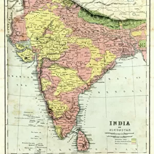
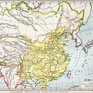
Framed Print : Map / Asia / India C1870


![]()
Framed Photos from Mary Evans Picture Library
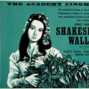
Map / Asia / India C1870
India, showing the various Presidencies under British rule
Mary Evans Picture Library makes available wonderful images created for people to enjoy over the centuries
Media ID 576624
© Mary Evans Picture Library 2015 - https://copyrighthub.org/s0/hub1/creation/maryevans/MaryEvansPictureID/10015675
22"x18" Modern Frame
Discover the rich history of India during the British colonial era with our exquisite framed print, "Map / Asia / India C1870" from Mary Evans Picture Library. This stunning vintage map, sourced from Mary Evans Prints Online, offers a captivating glimpse into the political landscape of India in the late 19th century, featuring the various Presidencies under British rule. Bring a touch of history and sophistication to your home or office with this beautifully framed, museum-quality print. Perfect for history enthusiasts, educators, or anyone seeking to add character to their space, this timeless piece is sure to be a conversation starter. Order yours today and start your collection of historical prints with Media Storehouse.
20x16 Print in an MDF Wooden Frame with 180 gsm Satin Finish Paper. Glazed using shatter proof thin plexiglass. Frame thickness is 1 inch and depth 0.75 inch. Fluted cardboard backing held with clips. Supplied ready to hang with sawtooth hanger and rubber bumpers. Spot clean with a damp cloth. Packaged foam wrapped in a card.
Contemporary Framed and Mounted Prints - Professionally Made and Ready to Hang
Estimated Image Size (if not cropped) is 45.7cm x 50.8cm (18" x 20")
Estimated Product Size is 45.7cm x 55.9cm (18" x 22")
These are individually made so all sizes are approximate
Artwork printed orientated as per the preview above, with portrait (vertical) orientation to match the source image.
FEATURES IN THESE COLLECTIONS
> Asia
> India
> Related Images
> Maps and Charts
> Early Maps
> Maps and Charts
> India
> Mary Evans Prints Online
> Maps
> Popular Themes
> Maps and Charts
EDITORS COMMENTS
This print of a historical map of India circa 1870 offers a fascinating glimpse into the country's past, specifically during the time when it was under British rule. The intricate details and borders on the map showcase the various Presidencies that existed at that time, providing valuable insight into the administrative divisions of India during this period.
The map not only serves as a visual representation of India's history but also highlights the influence and impact of British colonialism on the region. It is a reminder of a significant era in Indian history when political power was centralized in different regions under British control.
As we study this map, we are transported back in time to an era where boundaries were defined by colonial powers and cultures intersected in ways that shaped modern-day India. The meticulous craftsmanship and attention to detail on this map reflect both its historical significance and artistic value.
Overall, this print from Mary Evans Picture Library is not just a piece of art but also a valuable educational resource for those interested in exploring India's rich history and understanding how it has evolved over time under British rule.
MADE IN THE USA
Safe Shipping with 30 Day Money Back Guarantee
FREE PERSONALISATION*
We are proud to offer a range of customisation features including Personalised Captions, Color Filters and Picture Zoom Tools
SECURE PAYMENTS
We happily accept a wide range of payment options so you can pay for the things you need in the way that is most convenient for you
* Options may vary by product and licensing agreement. Zoomed Pictures can be adjusted in the Cart.