Home > Asia > India > Maps
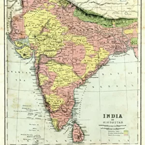
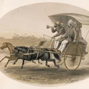
Canvas Print : Map / Asia / India C1850


![]()
Canvas Prints from Mary Evans Picture Library
Map / Asia / India C1850
India under British rule, about the time of the Mutiny
Mary Evans Picture Library makes available wonderful images created for people to enjoy over the centuries
Media ID 576626
© Mary Evans Picture Library 2015 - https://copyrighthub.org/s0/hub1/creation/maryevans/MaryEvansPictureID/10015681
20"x16" (51x41cm) Canvas Print
Introducing the captivating "Map / Asia / India C1850" canvas print from Mary Evans Picture Library, now available through Media Storehouse. This exquisite piece transports you back in time to the intriguing era of British rule in India, circa 1850. The map, sourced from Mary Evans Prints Online, offers an enlightening glimpse into the geographical landscape of Asia during the time of the Indian Mutiny. The intricate details of the map are beautifully rendered on high-quality canvas, ensuring a stunning addition to any room in your home or office. Decorate your space with a piece of history and add an element of sophistication to your interior design. Bring the past to life with the "Map / Asia / India C1850" canvas print from Media Storehouse.
Delivered stretched and ready to hang our premium quality canvas prints are made from a polyester/cotton blend canvas and stretched over a 1.25" (32mm) kiln dried knot free wood stretcher bar. Packaged in a plastic bag and secured to a cardboard insert for safe transit.
Canvas Prints add colour, depth and texture to any space. Professionally Stretched Canvas over a hidden Wooden Box Frame and Ready to Hang
Estimated Product Size is 40.6cm x 50.8cm (16" x 20")
These are individually made so all sizes are approximate
Artwork printed orientated as per the preview above, with portrait (vertical) orientation to match the source image.
FEATURES IN THESE COLLECTIONS
> Asia
> India
> Related Images
> Maps and Charts
> Early Maps
> Maps and Charts
> India
> Mary Evans Prints Online
> Maps
EDITORS COMMENTS
This print from Mary Evans Picture Library showcases a detailed map of Asia, specifically focusing on India around the year 1850. During this time, India was under British rule, and tensions were rising leading up to the Indian Mutiny.
The map itself is a fascinating glimpse into the past, showing the intricate borders and regions of India as it existed during this pivotal period in history. The level of detail in the map allows viewers to truly immerse themselves in the geography and political landscape of India at that time.
As we study this map, we can't help but reflect on the complex dynamics at play during this era - from colonialism to resistance movements. The presence of British rule looms large over the country, with implications that would shape India's future for generations to come.
Overall, this print serves as a powerful reminder of India's rich history and its struggles for independence. It captures a moment frozen in time when change was on the horizon and revolution was brewing. A true historical treasure that offers valuable insights into one of Asia's most influential nations during a critical juncture in its development.
MADE IN THE USA
Safe Shipping with 30 Day Money Back Guarantee
FREE PERSONALISATION*
We are proud to offer a range of customisation features including Personalised Captions, Color Filters and Picture Zoom Tools
FREE COLORIZATION SERVICE
You can choose advanced AI Colorization for this picture at no extra charge!
SECURE PAYMENTS
We happily accept a wide range of payment options so you can pay for the things you need in the way that is most convenient for you
* Options may vary by product and licensing agreement. Zoomed Pictures can be adjusted in the Cart.