Home > Europe > United Kingdom > England > Maps
Photographic Print : Map / Somerset C1857


![]()
Photo Prints from Mary Evans Picture Library
Map / Somerset C1857
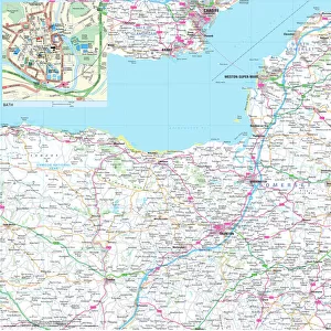
Map of Somerset
Mary Evans Picture Library makes available wonderful images created for people to enjoy over the centuries
Media ID 4357725
© Mary Evans Picture Library 2015 - https://copyrighthub.org/s0/hub1/creation/maryevans/MaryEvansPictureID/10113997
10"x8" Photo Print
Photo prints are produced on Kodak professional photo paper resulting in timeless and breath-taking prints which are also ideal for framing. The colors produced are rich and vivid, with accurate blacks and pristine whites, resulting in prints that are truly timeless and magnificent. Whether you're looking to display your prints in your home, office, or gallery, our range of photographic prints are sure to impress. Dimensions refers to the size of the paper in inches.
Our Photo Prints are in a large range of sizes and are printed on Archival Quality Paper for excellent colour reproduction and longevity. They are ideal for framing (our Framed Prints use these) at a reasonable cost. Alternatives include cheaper Poster Prints and higher quality Fine Art Paper, the choice of which is largely dependant on your budget.
Estimated Product Size is 25.4cm x 20.3cm (10" x 8")
These are individually made so all sizes are approximate
Artwork printed orientated as per the preview above, with landscape (horizontal) or portrait (vertical) orientation to match the source image.
FEATURES IN THESE COLLECTIONS
> Europe
> United Kingdom
> England
> Maps
> Europe
> United Kingdom
> England
> Somerset
> Related Images
> Maps and Charts
> Early Maps
EDITORS COMMENTS
This print of a map of Somerset from 1857 offers a fascinating glimpse into the history and geography of this beautiful English county. The intricate details and delicate lines on the map showcase the craftsmanship and precision that went into creating such an important historical document.
As we study this map, we can imagine what life was like in Somerset over 150 years ago. The towns, villages, rivers, and roads depicted on the map give us a sense of how people lived and traveled during that time period. It's almost like taking a step back in time to explore the landscape as it once was.
The rich history of Somerset is evident in every corner of this map, with each place name telling its own story. From bustling market towns to quiet rural hamlets, each location has its own unique character that adds to the charm of this historic document.
Whether you're a history buff, a lover of maps, or simply someone who appreciates fine artistry, this print is sure to capture your imagination. Display it proudly in your home or office as a conversation piece that will spark curiosity and admiration from all who see it.
Step into the past with this stunning print of Somerset from 1857 - a true treasure for anyone interested in exploring England's rich heritage through cartography.
MADE IN THE USA
Safe Shipping with 30 Day Money Back Guarantee
FREE PERSONALISATION*
We are proud to offer a range of customisation features including Personalised Captions, Color Filters and Picture Zoom Tools
SECURE PAYMENTS
We happily accept a wide range of payment options so you can pay for the things you need in the way that is most convenient for you
* Options may vary by product and licensing agreement. Zoomed Pictures can be adjusted in the Cart.