Home > Arts > Landscape paintings > Waterfall and river artworks > River artworks
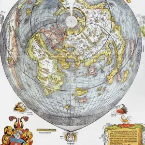
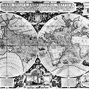
MAP OF THE WORLD, 1630. Detail of the Western Pacific from Philipp Eckbrecht s

![]()
Wall Art and Photo Gifts from Granger
MAP OF THE WORLD, 1630. Detail of the Western Pacific from Philipp Eckbrecht s
MAP OF THE WORLD, 1630.
Detail of the Western Pacific from Philipp Eckbrechts map of the world published at Nuremberg, Germany, in 1630
Granger holds millions of images spanning more than 25,000 years of world history, from before the Stone Age to the dawn of the Space Age
Media ID 12321094
1630 Detail Germany New World Pacific Ocean Philip World
FEATURES IN THESE COLLECTIONS
> Arts
> Landscape paintings
> Waterfall and river artworks
> River artworks
> Europe
> Germany
> Nuremberg
> Granger Art on Demand
> Maps
> Maps and Charts
> Early Maps
> Maps and Charts
> World
EDITORS COMMENTS
This print showcases a detailed section of the Western Pacific from Philipp Eckbrecht's historic "Map of the World" published in Nuremberg, Germany, in 1630. The map itself is a testament to the early exploration and cartography that shaped our understanding of the world during this period. In this particular detail, we are transported back in time to witness how Europeans perceived the vast expanse of the Pacific Ocean and its surrounding lands. The intricate lines and delicate shading depict various rivers flowing into the ocean, while islands dotting its surface hint at uncharted territories waiting to be discovered. Eckbrecht's map not only captures geographical features but also offers insights into cultural exchanges between different regions. It serves as a visual representation of Europe's growing curiosity about distant lands and their desire for global expansion. As we gaze upon this remarkable piece of history, we can't help but marvel at how far our knowledge has come since then. This print allows us to appreciate both the artistry involved in creating such maps centuries ago and their significant contribution to shaping our understanding of geography today. Whether you're an avid historian or simply fascinated by ancient cartography, this print will transport you back in time and ignite your imagination with tales of exploration across vast oceans towards unknown horizons.
MADE IN THE USA
Safe Shipping with 30 Day Money Back Guarantee
FREE PERSONALISATION*
We are proud to offer a range of customisation features including Personalised Captions, Color Filters and Picture Zoom Tools
SECURE PAYMENTS
We happily accept a wide range of payment options so you can pay for the things you need in the way that is most convenient for you
* Options may vary by product and licensing agreement. Zoomed Pictures can be adjusted in the Cart.