Home > Europe > United Kingdom > Wales > Maps
Photographic Print : Map of the Industries in England and Wales


![]()
Photo Prints from Mary Evans Picture Library
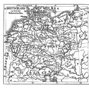
Map of the Industries in England and Wales
The location of the main places in England and Wales where items are made. Date: 1931
Mary Evans Picture Library makes available wonderful images created for people to enjoy over the centuries
Media ID 7214375
© Mary Evans Picture Library 2015 - https://copyrighthub.org/s0/hub1/creation/maryevans/MaryEvansPictureID/10214577
1931 Factories Industries Manufacturing Maps Products
14"x11" Photo Print
Discover the rich industrial heritage of England and Wales with our stunning photographic print from Media Storehouse. This captivating image, sourced from Mary Evans Prints Online, showcases a rare 1931 map detailing the locations of various industries across the regions. Travel back in time and explore the historical significance of each place where textiles, coal mining, steel production, and more thrived. Add a touch of history and character to your home or office decor with this intriguing and informative print.
Photo prints are produced on Kodak professional photo paper resulting in timeless and breath-taking prints which are also ideal for framing. The colors produced are rich and vivid, with accurate blacks and pristine whites, resulting in prints that are truly timeless and magnificent. Whether you're looking to display your prints in your home, office, or gallery, our range of photographic prints are sure to impress. Dimensions refers to the size of the paper in inches.
Our Photo Prints are in a large range of sizes and are printed on Archival Quality Paper for excellent colour reproduction and longevity. They are ideal for framing (our Framed Prints use these) at a reasonable cost. Alternatives include cheaper Poster Prints and higher quality Fine Art Paper, the choice of which is largely dependant on your budget.
Estimated Image Size (if not cropped) is 25cm x 35.5cm (9.8" x 14")
Estimated Product Size is 27.9cm x 35.5cm (11" x 14")
These are individually made so all sizes are approximate
Artwork printed orientated as per the preview above, with portrait (vertical) orientation to match the source image.
FEATURES IN THESE COLLECTIONS
> Europe
> United Kingdom
> England
> Maps
> Europe
> United Kingdom
> Wales
> Maps
> Europe
> United Kingdom
> Wales
> Related Images
> Maps and Charts
> Wales
EDITORS COMMENTS
1. Title: "A Glance into Industrial England and Wales: A 1931 Map Revealing the Heart of the Country's Manufacturing Sector" This vintage map, dated 1931, offers a fascinating glimpse into the industrial landscape of England and Wales during an era of significant economic growth and innovation. The map, titled "Industrial Map of England and Wales," meticulously illustrates the location of the principal places where various goods were manufactured across the two countries. The intricate details of this map reveal the extensive reach of industries, with factories and production centers dotting the landscape from the bustling cities to the rural areas. The map covers a wide range of industries, including textiles, metalworking, chemicals, food processing, and more. Notable industrial hubs, such as Manchester, Birmingham, and Sheffield, are clearly marked, showcasing their pivotal roles in the production of textiles, metal goods, and steel, respectively. The map also highlights the importance of the coal and iron industries in the Midlands and the North East, which fueled the growth of many factories and forges. As you delve deeper into this map, you'll discover the localized production of specific items. For instance, the West Midlands were known for their leather goods, while the North East was a center for glass manufacturing. The map also highlights the presence of major ports, such as Liverpool and Cardiff, which facilitated the import and export of raw materials and finished goods. This map serves as a testament to the rich industrial history of England and Wales, providing a unique perspective on the country's economic landscape during the early 20th century. It offers a captivating visual representation of the interconnectedness of various industries and their locations, showcasing the depth and breadth of the manufacturing sector in the region.
MADE IN THE USA
Safe Shipping with 30 Day Money Back Guarantee
FREE PERSONALISATION*
We are proud to offer a range of customisation features including Personalised Captions, Color Filters and Picture Zoom Tools
SECURE PAYMENTS
We happily accept a wide range of payment options so you can pay for the things you need in the way that is most convenient for you
* Options may vary by product and licensing agreement. Zoomed Pictures can be adjusted in the Cart.