Home > Maps and Charts > Early Maps
Framed Print : Map of the Crusades


![]()
Framed Photos from Mary Evans Picture Library
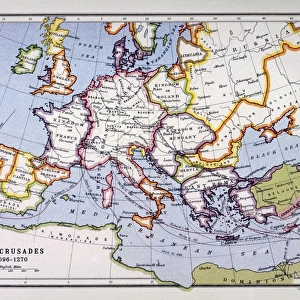
Map of the Crusades
Map of the Crusades, showing Europe, the Middle East and the Holy Land
Mary Evans Picture Library makes available wonderful images created for people to enjoy over the centuries
Media ID 4343269
© Mary Evans Picture Library 2015 - https://copyrighthub.org/s0/hub1/creation/maryevans/MaryEvansPictureID/10138352
22"x18" Modern Frame
Introducing the captivating "Map of the Crusades" Framed Print from Media Storehouse, an exquisite addition to your home or office decor. This intricately detailed map, sourced from Mary Evans Prints Online, transports you back in time to the historic Crusades, showcasing Europe, the Middle East, and the Holy Land. Each line and border on this rights-managed print represents a significant chapter in history, making it an engaging conversation starter. The high-quality print is beautifully framed, ensuring a stunning presentation that adds character and depth to any space. Bring a piece of history into your world with the "Map of the Crusades" Framed Print from Media Storehouse.
20x16 Print in an MDF Wooden Frame with 180 gsm Satin Finish Paper. Glazed using shatter proof thin plexiglass. Frame thickness is 1 inch and depth 0.75 inch. Fluted cardboard backing held with clips. Supplied ready to hang with sawtooth hanger and rubber bumpers. Spot clean with a damp cloth. Packaged foam wrapped in a card.
Contemporary Framed and Mounted Prints - Professionally Made and Ready to Hang
Estimated Image Size (if not cropped) is 50.8cm x 45.7cm (20" x 18")
Estimated Product Size is 55.9cm x 45.7cm (22" x 18")
These are individually made so all sizes are approximate
Artwork printed orientated as per the preview above, with landscape (horizontal) orientation to match the source image.
FEATURES IN THESE COLLECTIONS
> Europe
> Related Images
> Maps and Charts
> Early Maps
EDITORS COMMENTS
This print of the "Map of the Crusades" takes us on a journey back in time to one of the most significant and tumultuous periods in history. The map vividly illustrates Europe, the Middle East, and the Holy Land during the era of the Crusades, providing a detailed look at the lands where crucial historical events unfolded.
Dating back to around 1100 AD, this map showcases key locations such as Jerusalem, Constantinople, and various other cities that played pivotal roles in shaping the course of history during this period. The intricate details and geographical accuracy make it a valuable resource for historians and enthusiasts alike.
The Mediterranean Sea serves as a central point on this map, highlighting its importance as a strategic waterway during these times of war and conquest. The depiction of borders, territories, and battle sites offers insight into how political power shifted across regions over centuries.
As we study this historical land document from Rights Managed collection by Mary Evans Prints Online, we are reminded of the complex interplay between religion, politics, and warfare that defined an entire epoch. It is truly fascinating to see how different civilizations clashed and coexisted in pursuit of their beliefs and ambitions across Europe and the Middle East.
MADE IN THE USA
Safe Shipping with 30 Day Money Back Guarantee
FREE PERSONALISATION*
We are proud to offer a range of customisation features including Personalised Captions, Color Filters and Picture Zoom Tools
SECURE PAYMENTS
We happily accept a wide range of payment options so you can pay for the things you need in the way that is most convenient for you
* Options may vary by product and licensing agreement. Zoomed Pictures can be adjusted in the Cart.