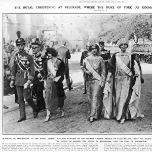
Home > Europe > Slovenia > Related Images
Jigsaw Puzzle : Map of Slovenia 1689


![]()
Jigsaw Puzzles from Mary Evans Picture Library
Map of Slovenia 1689
The mountain JAVORNIKI is shown here to the north of the town CERKNIKA. In reality the town is north of the mountain
Mary Evans Picture Library makes available wonderful images created for people to enjoy over the centuries
Media ID 597861
© Mary Evans Picture Library 2015 - https://copyrighthub.org/s0/hub1/creation/maryevans/MaryEvansPictureID/10147653
1689 Maps Reality Shown Slovenia
Jigsaw Puzzle (252 Pieces)
Discover the captivating history of Slovenia with our intricately designed Jigsaw Puzzle from Media Storehouse and Mary Evans Picture Library. Feast your eyes on the mesmerizing "Map of Slovenia 1689," an exquisite representation of the region's rich past. Delve into the intricacies of this 500-piece puzzle, featuring the stunning landscape of the Javorniki Mountains to the south of the town of Cerknica. Though the map's depiction may show the mountain range in a different location than its actual position, the puzzle promises an engaging and educational experience for puzzle enthusiasts and history buffs alike. With its intricate details and captivating imagery, this puzzle is the perfect addition to any home or office. Once completed, display it as a conversation starter, a reminder of the fascinating history of Slovenia, or simply as a beautiful work of art. Embrace the challenge and embark on a journey of discovery with the Media Storehouse Map of Slovenia 1689 Jigsaw Puzzle.
Made in the USA, 252-piece puzzles measure 11" x 14" (27.9 x 35.5 cm). Every puzzle is meticulously printed on glossy photo paper, which has a strong 1.33 mm thickness. Delivered in a black storage cardboard box, these puzzles are both stylish and practical. (Note: puzzles contain small parts and are not suitable for children under 3 years of age.)
Jigsaw Puzzles are an ideal gift for any occasion
Estimated Product Size is 35.6cm x 28cm (14" x 11")
These are individually made so all sizes are approximate
Artwork printed orientated as per the preview above, with landscape (horizontal) orientation to match the source image.
EDITORS COMMENTS
This fascinating historical map of Slovenia from 1689 offers a glimpse into the past, showcasing the town of Cerknika and the mountain Javoriniki in Eastern Europe. Interestingly, the positioning on this map is slightly inaccurate, as in reality, the town is actually situated north of the mountain. Despite this small discrepancy, this intricate depiction provides valuable insights into the geography and history of Slovenia during that time period.
The detailed cartography highlights various towns, mountains, and rivers throughout the region, offering a comprehensive view of Slovenia in 1689. The inclusion of Javoriniki to the north of Cerknika adds an interesting element to this map, prompting viewers to consider how perceptions of geography have evolved over centuries.
As we study this historical document closely, we are transported back in time to a different era when maps were meticulously hand-drawn and served as essential tools for navigation and exploration. The intricate details and artistic flair present on this map showcase both practicality and beauty in cartography.
Overall, this print from Mary Evans Picture Library serves as a valuable historical artifact that sheds light on Slovenia's past while also reminding us of the complexities involved in accurately representing geographical features on maps.
MADE IN THE USA
Safe Shipping with 30 Day Money Back Guarantee
FREE PERSONALISATION*
We are proud to offer a range of customisation features including Personalised Captions, Color Filters and Picture Zoom Tools
SECURE PAYMENTS
We happily accept a wide range of payment options so you can pay for the things you need in the way that is most convenient for you
* Options may vary by product and licensing agreement. Zoomed Pictures can be adjusted in the Cart.