Home > Oceania > Australia > Maps
Canvas Print : Map of Australia


Canvas Prints from Mary Evans Picture Library
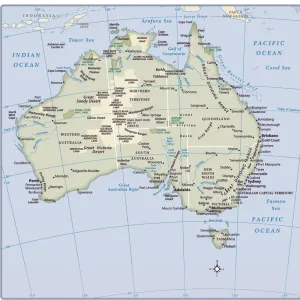
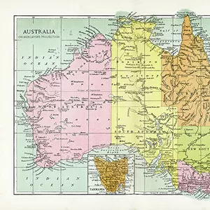
Map of Australia
Map of Australia, showing her natural and industrial resources.
20th century
Mary Evans Picture Library makes available wonderful images created for people to enjoy over the centuries
Media ID 7177883
© Mary Evans Picture Library 2015 - https://copyrighthub.org/s0/hub1/creation/maryevans/MaryEvansPictureID/10507938
Australasia Maps Pacific Resources Southern Tasmania War Time
12"x9" (30x23cm) Canvas Print
Discover the beauty and richness of Australia with our exquisite Canvas Prints from Media Storehouse, featuring the captivating "Map of Australia" by Mary Evans Picture Library/Onslow Auctions Limited. This vintage map, hailing from the 20th century, showcases Australia's diverse natural and industrial resources. Each print is meticulously reproduced on high-quality canvas, ensuring vibrant colors and exceptional detail. Bring the essence of this fascinating land into your home or office, and let the intrigue of Australia's history and geography captivate you every day. Order now and join the many satisfied customers who have transformed their spaces with Media Storehouse's stunning Canvas Prints.
Delivered stretched and ready to hang our premium quality canvas prints are made from a polyester/cotton blend canvas and stretched over a 1.25" (32mm) kiln dried knot free wood stretcher bar. Packaged in a plastic bag and secured to a cardboard insert for safe transit.
Canvas Prints add colour, depth and texture to any space. Professionally Stretched Canvas over a hidden Wooden Box Frame and Ready to Hang
Estimated Image Size (if not cropped) is 30.4cm x 20.4cm (12" x 8")
Estimated Product Size is 30.5cm x 22.9cm (12" x 9")
These are individually made so all sizes are approximate
Artwork printed orientated as per the preview above, with landscape (horizontal) orientation to match the source image.
FEATURES IN THESE COLLECTIONS
EDITORS COMMENTS
This vintage poster showcases a detailed map of Australia from the 20th century, highlighting the vast natural and industrial resources that have shaped the country's history. The map extends from the tropical north, where the Indian Ocean meets the northern tip of Australia, to the arid outback, and the lush green lands of Tasmania in the south. The map's intricate design reveals an abundance of natural resources, including forests, rivers, and mineral deposits. The rich agricultural lands are depicted in verdant green, while the vast deserts and arid regions are shown in earthy browns and reds. The coastal areas, dotted with bays and inlets, are outlined in crisp blue, with the Southern Ocean lapping at the shores. The industrial resources are also prominently featured, with coal mines and oil fields marked in black, and iron and copper mines shown in red and green, respectively. The map also highlights the strategic locations of major ports and shipping lanes, emphasizing Australia's importance as a key player in maritime trade. The poster carries a sense of history, with the map's border adorned with military insignia, reminding us of Australia's involvement in various wars, particularly during the 20th century. The poster's title, "Australia and New Zealand - Map of the Australian Continent and the Islands of the Pacific and Indian Oceans," further emphasizes the geographical significance of the region during that era. This stunning poster is a testament to the rich natural and industrial heritage of Australia and the broader Australasian region. Its intricate design and historical significance make it a must-have for collectors of vintage maps and Australian history.
MADE IN THE USA
Safe Shipping with 30 Day Money Back Guarantee
FREE PERSONALISATION*
We are proud to offer a range of customisation features including Personalised Captions, Color Filters and Picture Zoom Tools
SECURE PAYMENTS
We happily accept a wide range of payment options so you can pay for the things you need in the way that is most convenient for you
* Options may vary by product and licensing agreement. Zoomed Pictures can be adjusted in the Cart.