Home > Asia > Iraq > Maps
Jigsaw Puzzle : Map of Arabia Deserta


![]()
Jigsaw Puzzles from Mary Evans Picture Library
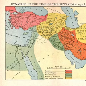
Map of Arabia Deserta
Map of Arabia Petraea et Deserta, including much of northern Iraq. Petra is down on the left, a few centimetres above the word felicis
Mary Evans Picture Library makes available wonderful images created for people to enjoy over the centuries
Media ID 4370516
© Mary Evans Picture Library 2015 - https://copyrighthub.org/s0/hub1/creation/maryevans/MaryEvansPictureID/10193807
Arabia Including Iraq Maps Petra Word Centimetres Petraea
Jigsaw Puzzle (252 Pieces)
Discover the wonders of ancient Arabia with our captivating jigsaw puzzles from Media Storehouse. This intriguing puzzle features the Map of Arabia Petraea et Deserta, an exquisite historical map from Mary Evans Prints Online. Delve into the rich history of the region, tracing the borders of ancient civilizations and uncovering hidden treasures. With intricate details and vivid colors, this puzzle is a perfect challenge for puzzle enthusiasts and history buffs alike. Get ready to embark on an adventure and piece together this beautiful representation of a bygone era.
Made in the USA, 252-piece puzzles measure 11" x 14" (27.9 x 35.5 cm). Every puzzle is meticulously printed on glossy photo paper, which has a strong 1.33 mm thickness. Delivered in a black storage cardboard box, these puzzles are both stylish and practical. (Note: puzzles contain small parts and are not suitable for children under 3 years of age.)
Jigsaw Puzzles are an ideal gift for any occasion
Estimated Product Size is 35.6cm x 28cm (14" x 11")
These are individually made so all sizes are approximate
Artwork printed orientated as per the preview above, with landscape (horizontal) orientation to match the source image.
FEATURES IN THESE COLLECTIONS
> Asia
> Iraq
> Related Images
> Maps and Charts
> Early Maps
EDITORS COMMENTS
This stunning historical map of Arabia Deserta, dating back to the 18th century, offers a fascinating glimpse into the geography of the region including much of northern Iraq. The intricate details on this map showcase important landmarks such as Petra, located down on the left side just a few centimetres above the word "felicis".
As you study this piece of history, you can see how meticulously crafted it is with precise markings and labels that provide valuable insights into the past. The Map of Arabia Petraea et Deserta not only serves as a navigational tool but also as a window into the rich history and culture of this ancient land.
From its depiction of trade routes to geographical features, this map captures the essence of Arabia in all its glory. It is a reminder of how maps have played a crucial role in shaping our understanding of different regions and their significance throughout time.
Whether you are a history enthusiast or simply appreciate fine cartography, this print from Mary Evans Prints Online is sure to captivate your imagination and transport you back to an era where exploration and discovery were at the forefront.
MADE IN THE USA
Safe Shipping with 30 Day Money Back Guarantee
FREE PERSONALISATION*
We are proud to offer a range of customisation features including Personalised Captions, Color Filters and Picture Zoom Tools
SECURE PAYMENTS
We happily accept a wide range of payment options so you can pay for the things you need in the way that is most convenient for you
* Options may vary by product and licensing agreement. Zoomed Pictures can be adjusted in the Cart.