Home > Europe > United Kingdom > Wales > Powys > Newtown
Tameside M34 6 Map

![]()
Wall Art and Photo Gifts from Map Marketing
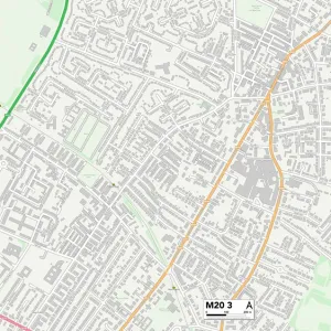
Tameside M34 6 Map
Postcode Sector Map of Tameside M34 6
Media ID 19974218
Acacia Avenue Albert Street Alder Grove Broadfield Close Carter Close Cemetery Road Chapel Green Chester Street Circular Road Clayton Street Cypress Grove Denton Duke Street Fir Road Foster Street Holly Grove King Street Langdale Close Larch Road Linden Road Marie Close Market Street Mount Pleasant Road Pendle Road Pine Grove Rectory Close Scott Road Smith Street Southern Close St Lawrence Road Stockport Road Sycamore Avenue Tameside West Lea Weston Drive Yew Tree Road
FEATURES IN THESE COLLECTIONS
> Arts
> Portraits
> Pop art gallery
> Street art portraits
> Europe
> United Kingdom
> Wales
> Powys
> Newtown
> Map Marketing
> Postcode Sector Maps
> M - Manchester
> Map Marketing
> UK Maps
> Maps and Charts
> Related Images
MADE IN THE USA
Safe Shipping with 30 Day Money Back Guarantee
FREE PERSONALISATION*
We are proud to offer a range of customisation features including Personalised Captions, Color Filters and Picture Zoom Tools
SECURE PAYMENTS
We happily accept a wide range of payment options so you can pay for the things you need in the way that is most convenient for you
* Options may vary by product and licensing agreement. Zoomed Pictures can be adjusted in the Cart.