Home > Animals > Mammals > Bovidae > Ox
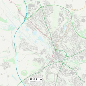
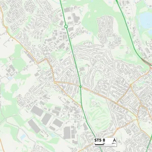
Staffordshire ST13 7 Map

![]()
Wall Art and Photo Gifts from Map Marketing
Staffordshire ST13 7 Map
Postcode Sector Map of Staffordshire ST13 7
Media ID 19981938
Ashbourne Road Ashcombe Road Beech Avenue Beech Close Blackbrook Bluebell Close Bottom Lane Brookhouse Lane Brooklands Way Cheadle Road Chestnut Walk Churchill Avenue Cooks Lane Cross Lane Dog Lane Dukes Lane East Drive Folly Lane Ford Grange Road Harrison Way High Lane Hillside Road Hollow Lane Holly Avenue Knowsley Road Leek Road Maple Grove Moorland Road Oak Avenue Park Lane Parsons Lane Porters Lane Primrose Close School Lane St Edwards Road Staffordshire Station Road The Avenue The Croft The Heights The Oaks Thorncliffe Road Vale View Villa Road West Drive Westwood Close Willow Drive Woodland Avenue Woodside Lane Millstone Edge Thorncliffe
FEATURES IN THESE COLLECTIONS
> Animals
> Mammals
> Bovidae
> Ox
> Animals
> Mammals
> Muridae
> Heath Mouse
> Animals
> Mammals
> Muridae
> House Mouse
> Europe
> United Kingdom
> England
> Staffordshire
> Basford Green
> Europe
> United Kingdom
> England
> Staffordshire
> Beech
> Europe
> United Kingdom
> England
> Staffordshire
> Blackbrook
> Europe
> United Kingdom
> England
> Staffordshire
> Butterton
> Europe
> United Kingdom
> England
> Staffordshire
> Cauldon
> Europe
> United Kingdom
> England
> Staffordshire
> Cheadle
> Europe
> United Kingdom
> England
> Staffordshire
> Cheddleton
> Map Marketing
> Postcode Sector Maps
> ST - Stoke-on-Trent
> Map Marketing
> UK Maps
MADE IN THE USA
Safe Shipping with 30 Day Money Back Guarantee
FREE PERSONALISATION*
We are proud to offer a range of customisation features including Personalised Captions, Color Filters and Picture Zoom Tools
SECURE PAYMENTS
We happily accept a wide range of payment options so you can pay for the things you need in the way that is most convenient for you
* Options may vary by product and licensing agreement. Zoomed Pictures can be adjusted in the Cart.