Home > Arts > Artists > B > Charles Brooking
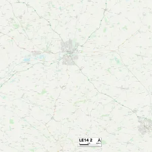
County Durham SR8 3 Map

![]()
Wall Art and Photo Gifts from Map Marketing
County Durham SR8 3 Map
Postcode Sector Map of County Durham SR8 3
Media ID 19981528
Allan Street Andrews Lane Angus Street Ashton Street Avon Street Baldwin Street Blind Lane Boston Street Brampton Court Browning Street Camp Street Campbell Street Cardiff Street Carlton Terrace Castle Street Charles Street Church Walk Cornwall Street County Durham Court Street Easington Glenhurst Road Grange Avenue Hawthorn Street Highgrove Court Lea Lane Memorial Avenue Mill Hill Milton Lane North Crescent Nursery Gardens Paradise Lane Rosemary Lane Rydal Mount School Street Seaton Close South Side St Marys Close St Thomas Close Station Road Stewart Street Stockton Road Sunderland Road Tennyson Road The Coppice The Crescent The Grove The Spinney Thomas Street Thorpe Road Thorpe Street Vane Street Vincent Street Windsor Court Wordsworth Road
FEATURES IN THESE COLLECTIONS
> Arts
> Artists
> B
> Charles Brooking
> Arts
> Artists
> B
> Thomas Brooks
> Arts
> Artists
> C
> Craig Craig
> Arts
> Artists
> C
> Thomas Campbell
> Arts
> Artists
> H
> Thomas Hill
> Arts
> Artists
> N
> Thomas North
> Arts
> Artists
> S
> Thomas Sunderland
> Arts
> Artists
> T
> Thomas Thorpe
> Arts
> Portraits
> Pop art gallery
> Street art portraits
> Europe
> United Kingdom
> England
> Avon
> Map Marketing
> Postcode Sector Maps
> SR - Sunderland
MADE IN THE USA
Safe Shipping with 30 Day Money Back Guarantee
FREE PERSONALISATION*
We are proud to offer a range of customisation features including Personalised Captions, Color Filters and Picture Zoom Tools
SECURE PAYMENTS
We happily accept a wide range of payment options so you can pay for the things you need in the way that is most convenient for you
* Options may vary by product and licensing agreement. Zoomed Pictures can be adjusted in the Cart.