Home > Europe > United Kingdom > Scotland > Fife > St Andrews
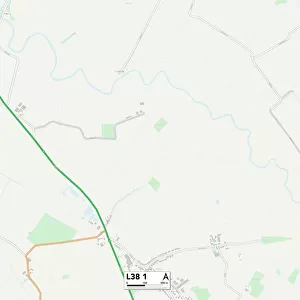
Sefton L37 2 Map

![]()
Wall Art and Photo Gifts from Map Marketing
Sefton L37 2 Map
Postcode Sector Map of Sefton L37 2
Media ID 19974185
Albert Road Alexandra Road Andrews Close Andrews Lane Ash Grove Ashdale Close Aspen Grove Beechwood Drive Brooks Road Buckingham Grove Cambridge Road Cedar Drive Chestnut Way Church Green Church Way Coniston Road Crescent Avenue Derwent Avenue Eccles Road Elm Drive Ennerdale Road Eskdale Close Eskdale Drive Foster Road Foxhill Close Grasmere Road Jubilee Road Kew Road Langdale Avenue Langdale Close Maple Close Mayfield Avenue Mere Road Milford Close Orwell Close Pinewood Avenue Pinewood Close Queens Road Rydal Avenue Sandhurst Close Sefton Sefton Road Springfield Close Spruce Way Stapleton Road Sutton Road Sycamore Grove Ward Avenue Woodlands Close Woodlands Road
FEATURES IN THESE COLLECTIONS
> Asia
> Georgia
> Related Images
> Europe
> United Kingdom
> Scotland
> Fife
> St Andrews
> Map Marketing
> Postcode Sector Maps
> L - Liverpool
> Map Marketing
> UK Maps
> Maps and Charts
> Related Images
MADE IN THE USA
Safe Shipping with 30 Day Money Back Guarantee
FREE PERSONALISATION*
We are proud to offer a range of customisation features including Personalised Captions, Color Filters and Picture Zoom Tools
SECURE PAYMENTS
We happily accept a wide range of payment options so you can pay for the things you need in the way that is most convenient for you
* Options may vary by product and licensing agreement. Zoomed Pictures can be adjusted in the Cart.