Home > Europe > United Kingdom > England > Hampshire > Ashford Hill
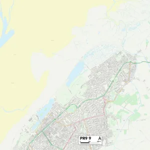
Maidstone ME17 1 Map

![]()
Wall Art and Photo Gifts from Map Marketing
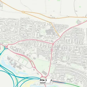
Maidstone ME17 1 Map
Postcode Sector Map of Maidstone ME17 1
Media ID 19974706
Abbotts Way Alexander Road Ashford Road Back Street Brick Kiln Lane Broad Street Broomfield Broomfield Road Buckingham Drive Butler Close Castle Drive Chestnut Close Church Crescent Church Green Church Lane Church Road Churchfields Claygate Copperfield Drive Cricketers Close Dickens Close Downlands East Street Eastwood Eastwood Road Field Close Forge Lane Friars Close George Lane Greenway Lane Harrison Drive Headcorn Road Hook Lane Hospital Road Kings Close Lacey Close Leeds Lodge Gardens Lower Street Maidstone Marley Road Mayfield Meadow View Meredith Close Millers Way Monks Drive Old Mill Lane Old Mill Road Parkfield Close Pilgrims Close Pilgrims Way Pye Corner Rectory Lane Reeves Close Station Road Taylor Close The Street Upper Street Water Lane West Street Willow Close Windmill Hill Yeomans Way Bakers Yard Caring
FEATURES IN THESE COLLECTIONS
> Animals
> Mammals
> Muridae
> Heath Mouse
> Animals
> Mammals
> Muridae
> Water Mouse
> Arts
> Artists
> A
> Francis Alexander
> Arts
> Artists
> B
> George Baker
> Arts
> Artists
> B
> George Back
> Arts
> Artists
> D
> Francis Drake
> Arts
> Artists
> P
> Francis Place
> Arts
> Artists
> Y
> Art Young
> Arts
> Portraits
> Pop art gallery
> Street art portraits
> Europe
> United Kingdom
> England
> Hampshire
> Ashford Hill
> Map Marketing
> Postcode Sector Maps
> ME - Rochester
MADE IN THE USA
Safe Shipping with 30 Day Money Back Guarantee
FREE PERSONALISATION*
We are proud to offer a range of customisation features including Personalised Captions, Color Filters and Picture Zoom Tools
SECURE PAYMENTS
We happily accept a wide range of payment options so you can pay for the things you need in the way that is most convenient for you
* Options may vary by product and licensing agreement. Zoomed Pictures can be adjusted in the Cart.