Home > Europe > United Kingdom > Wales > Flintshire > Flint
Northampton NN4 6 Map

![]()
Wall Art and Photo Gifts from Map Marketing
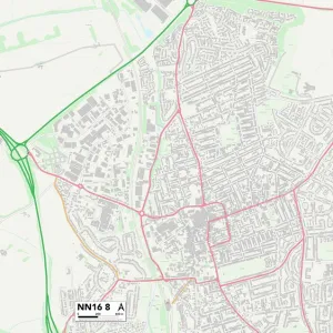
Northampton NN4 6 Map
Postcode Sector Map of Northampton NN4 6
Media ID 19975940
Bancroft Close Berry Lane Brooks Close Centurion Way Chestnut Avenue Church Hill Church View Clover Lane Cornflower Close Elm Grove Farmers Close Glebe Avenue Glebe Close Glebe Way Green Lane Hardy Drive Harris Close High Street High View Kirby Close Langford Drive Long Meadow Martins Lane Massey Close New Road Northampton Orchard Close Pioneer Close Quebec Close Robinson Way Roman Close Roman Way Sorrel Close Spartan Close Springfield Stockwell Avenue Stratford Drive Sunnyside The Ashes The Green The Warren Walkers Way Water Lane Windrush Road Woodgate Road Wootton
FEATURES IN THESE COLLECTIONS
> Animals
> Mammals
> Muridae
> Water Mouse
> Arts
> Artists
> R
> Roman Roman
> Arts
> Portraits
> Pop art gallery
> Street art portraits
> Europe
> United Kingdom
> Wales
> Flintshire
> Flint
> Europe
> United Kingdom
> Wales
> Gwent
> Newport
> Europe
> United Kingdom
> Wales
> Pembrokeshire
> Newport
> Map Marketing
> Postcode Sector Maps
> NN - Northampton
> Maps and Charts
> Related Images
MADE IN THE USA
Safe Shipping with 30 Day Money Back Guarantee
FREE PERSONALISATION*
We are proud to offer a range of customisation features including Personalised Captions, Color Filters and Picture Zoom Tools
SECURE PAYMENTS
We happily accept a wide range of payment options so you can pay for the things you need in the way that is most convenient for you
* Options may vary by product and licensing agreement. Zoomed Pictures can be adjusted in the Cart.