Home > Europe > United Kingdom > Wales > West Glamorgan > Port Talbot
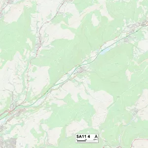
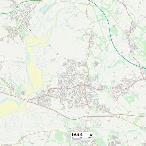
Neath Port Talbot SA10 7 Map

![]()
Wall Art and Photo Gifts from Map Marketing
Neath Port Talbot SA10 7 Map
Postcode Sector Map of Neath Port Talbot SA10 7
Media ID 19977744
A465 Benedict Close Birchwood Close Briarwood Close Brookfield Bryn Heulog Brynglas Channel View Chestnut Close Church Close Crud Yr Awel Dyffryn Road Fair View Firwood Close Friars Close Glendale Heol Y Felin Heol Y Nant Hill Road Larkspur Close Linden Close Llys Y Coed Longford Road Maplewood Close Margaret Street Mill Race Mill Road Monks Close Neath Port Talbot Neath Road Oakland Drive Parry Close Pentwyn Pilgrims Close Princess Drive Redwood Close Riverside Drive Roman Way Rosewood Close St Johns Terrace Sunnybank The Drive The Rickyard Tudor Gardens Village Close Dyffryn Mountain Stream Neath Abbey Rhiwlas
FEATURES IN THESE COLLECTIONS
> Arts
> Artists
> H
> John Hillers
> Arts
> Artists
> H
> John Hills
> Arts
> Artists
> R
> Roman Roman
> Arts
> Artists
> W
> John Wood
> Arts
> Portraits
> Pop art gallery
> Street art portraits
> Europe
> United Kingdom
> Wales
> West Glamorgan
> Neath
> Europe
> United Kingdom
> Wales
> West Glamorgan
> Port Talbot
> Map Marketing
> Postcode Sector Maps
> SA - Swansea
> Maps and Charts
> Related Images
MADE IN THE USA
Safe Shipping with 30 Day Money Back Guarantee
FREE PERSONALISATION*
We are proud to offer a range of customisation features including Personalised Captions, Color Filters and Picture Zoom Tools
SECURE PAYMENTS
We happily accept a wide range of payment options so you can pay for the things you need in the way that is most convenient for you
* Options may vary by product and licensing agreement. Zoomed Pictures can be adjusted in the Cart.