Home > Arts > Artists > B > Charles Broughton
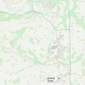
Wrexham LL11 5 Map

![]()
Wall Art and Photo Gifts from Map Marketing
Wrexham LL11 5 Map
Postcode Sector Map of Wrexham LL11 5
Media ID 19973954
Ael Y Bryn Bank Street Bridge Street Broughton Road Bryn Road Cefn Road Chapel Court Charles Street Church Road Coleman Road College Fields College Hill Colliery Road Davies Avenue Fairfield Farm Lane Ffordd Las Ffordd Newydd Forge Close Green Road Greenway Drive High Street Holland Road Kent Road Lime Street Meadow View Miller Road Mountain View New Road Park Road Phoenix Drive Queens Road Railway Road Ruthin Road Smithy Road St Albans Road St Johns Mews Swallowfields The Nurseries The Spinney Valley Road Vicarage Road Waterside Way Wesley Road Wrexham Blaenau Maesteg Southsea
FEATURES IN THESE COLLECTIONS
> Arts
> Artists
> B
> Charles Broughton
> Arts
> Artists
> F
> John Field
> Arts
> Artists
> G
> Charles Green
> Arts
> Artists
> H
> John Hillers
> Arts
> Artists
> H
> John Hills
> Arts
> Artists
> M
> John Miller
> Arts
> Portraits
> Pop art gallery
> Street art portraits
> Europe
> United Kingdom
> England
> Cheshire
> Related Images
> Europe
> United Kingdom
> England
> Cheshire
> Smithy Green
> Europe
> United Kingdom
> England
> Kent
> Bridge
> Map Marketing
> Postcode Sector Maps
> LL - Llandudno
MADE IN THE USA
Safe Shipping with 30 Day Money Back Guarantee
FREE PERSONALISATION*
We are proud to offer a range of customisation features including Personalised Captions, Color Filters and Picture Zoom Tools
SECURE PAYMENTS
We happily accept a wide range of payment options so you can pay for the things you need in the way that is most convenient for you
* Options may vary by product and licensing agreement. Zoomed Pictures can be adjusted in the Cart.