Home > Arts > Artists > W > Wilson Wilson
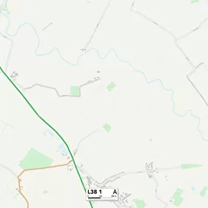
Knowsley L36 6 Map

![]()
Wall Art and Photo Gifts from Map Marketing
Knowsley L36 6 Map
Postcode Sector Map of Knowsley L36 6
Media ID 19974147
Attlee Road Brickfields Brighton Road Byron Close Derby Street Elm Street Hall Lane Henderson Road Hillcrest Avenue Knowsley Lansbury Road Link Road Lynton Road North View Paignton Close Parkside Close Poplar Way Russell Road School Lane Skipton Road South View Station Way Taunton Road The Crescent Tiverton Close West View West View Avenue West View Close Wilson Road Wood Lane
FEATURES IN THESE COLLECTIONS
> Arts
> Artists
> W
> Wilson Wilson
> Arts
> Portraits
> Pop art gallery
> Street art portraits
> Map Marketing
> Postcode Sector Maps
> L - Liverpool
> Maps and Charts
> Related Images
MADE IN THE USA
Safe Shipping with 30 Day Money Back Guarantee
FREE PERSONALISATION*
We are proud to offer a range of customisation features including Personalised Captions, Color Filters and Picture Zoom Tools
SECURE PAYMENTS
We happily accept a wide range of payment options so you can pay for the things you need in the way that is most convenient for you
* Options may vary by product and licensing agreement. Zoomed Pictures can be adjusted in the Cart.