Home > Europe > United Kingdom > Wales > Powys > Presteigne
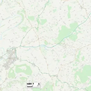
Hereford HR6 9 Map

![]()
Wall Art and Photo Gifts from Map Marketing
Hereford HR6 9 Map
Postcode Sector Map of Hereford HR6 9
Media ID 19972204
Aston Bacon Lane Bateman Close Bridge Street Castle Street Chapel Lane Church Crescent Church Green Church Road Church Street Cornhill Road Court Meadow Croft Lane Dog Lane East Street Ford Street Glen View Hereford High Street Highfield Close Kings Meadow Kingsland Longford Lower Green Marston Marston Lane Mowbray Close North Road Old Road Orchard Close Parsons Walk School Lane Spout Lane St Marys Walk St Marys Way St Michaels Avenue The Birches The Grove The Laurels Tudor Place West Street West Town Woodgate Lane Bearwood Bicton Easthampton Headland Lawton Pembridge Wigmore
FEATURES IN THESE COLLECTIONS
> Animals
> Birds
> Owls
> Related Images
> Animals
> Mammals
> Muridae
> Heath Mouse
> Arts
> Portraits
> Pop art gallery
> Street art portraits
> Europe
> United Kingdom
> England
> Herefordshire
> Maps
> Europe
> United Kingdom
> Wales
> Powys
> Presteigne
> Map Marketing
> Postcode Sector Maps
> HR - Hereford
> Maps and Charts
> Related Images
MADE IN THE USA
Safe Shipping with 30 Day Money Back Guarantee
FREE PERSONALISATION*
We are proud to offer a range of customisation features including Personalised Captions, Color Filters and Picture Zoom Tools
SECURE PAYMENTS
We happily accept a wide range of payment options so you can pay for the things you need in the way that is most convenient for you
* Options may vary by product and licensing agreement. Zoomed Pictures can be adjusted in the Cart.