Home > Europe > United Kingdom > England > London > Boroughs > Havering
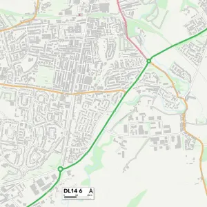
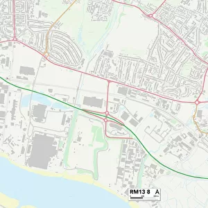
Havering RM2 6 Map

![]()
Wall Art and Photo Gifts from Map Marketing
Havering RM2 6 Map
Postcode Sector Map of Havering RM2 6
Media ID 19979125
Beaumont Close Belgrave Avenue Brentwood Road Cambridge Avenue Compton Avenue Cranbrook Drive Crossways Durham Avenue Edward Close Fairholme Avenue Ferguson Avenue Hall Road Havering Hopkins Close Links Avenue Main Road Montrose Avenue Mulberry Close North Drive Pinecroft Severn Avenue South Drive Station Road Thomas Drive Warwick Gardens Western Avenue
FEATURES IN THESE COLLECTIONS
> Animals
> Mammals
> Muridae
> Heath Mouse
> Animals
> Mammals
> Muridae
> Western Mouse
> Animals
> Mammals
> Squirrel
> Arts
> Artists
> N
> Thomas North
> Europe
> United Kingdom
> England
> Durham
> Durham
> Europe
> United Kingdom
> England
> London
> Boroughs
> Havering
> Europe
> United Kingdom
> England
> London
> Politics
> Edward Heath
> Europe
> United Kingdom
> Scotland
> Angus
> Montrose
> Map Marketing
> Postcode Sector Maps
> RM - Romford
> Maps and Charts
> Related Images
MADE IN THE USA
Safe Shipping with 30 Day Money Back Guarantee
FREE PERSONALISATION*
We are proud to offer a range of customisation features including Personalised Captions, Color Filters and Picture Zoom Tools
SECURE PAYMENTS
We happily accept a wide range of payment options so you can pay for the things you need in the way that is most convenient for you
* Options may vary by product and licensing agreement. Zoomed Pictures can be adjusted in the Cart.