Home > Europe > United Kingdom > England > London > Boroughs > Harrow
East Hampshire GU32 2 Map

![]()
Wall Art and Photo Gifts from Map Marketing
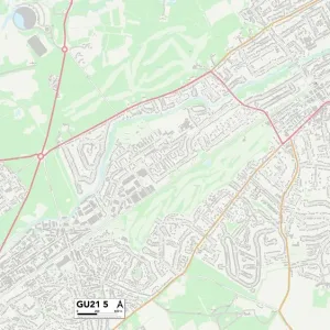
East Hampshire GU32 2 Map
Postcode Sector Map of East Hampshire GU32 2
Media ID 19971315
Balmoral Way Bell Hill Charlton Drive Church Road East Hampshire Farnham Road Hardy Avenue Harrow Lane Highfield Road King George Avenue Long Road Lynton Road Meon Close Mill Lane North Road Oaklands Road Osborne Road Sandringham Road Sandy Lane School Lane Stafford Road Stanton Road Station Road Town Lane Waterworks Road Sheet
FEATURES IN THESE COLLECTIONS
> Europe
> United Kingdom
> England
> Hampshire
> Charlton
> Europe
> United Kingdom
> England
> Hampshire
> East Meon
> Europe
> United Kingdom
> England
> Hampshire
> Mill Lane
> Europe
> United Kingdom
> England
> Hampshire
> Meon
> Europe
> United Kingdom
> England
> Hampshire
> North Town
> Europe
> United Kingdom
> England
> Hampshire
> Related Images
> Europe
> United Kingdom
> England
> Hampshire
> Selborne
> Europe
> United Kingdom
> England
> Hampshire
> Sheet
> Europe
> United Kingdom
> England
> Hampshire
> Steep
> Europe
> United Kingdom
> England
> London
> Boroughs
> Harrow
> Map Marketing
> Postcode Sector Maps
> GU - Guildford
MADE IN THE USA
Safe Shipping with 30 Day Money Back Guarantee
FREE PERSONALISATION*
We are proud to offer a range of customisation features including Personalised Captions, Color Filters and Picture Zoom Tools
SECURE PAYMENTS
We happily accept a wide range of payment options so you can pay for the things you need in the way that is most convenient for you
* Options may vary by product and licensing agreement. Zoomed Pictures can be adjusted in the Cart.