Home > Europe > United Kingdom > Wales > Powys > Montgomery
Warwick CV35 8 Map

![]()
Wall Art and Photo Gifts from Map Marketing
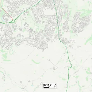
Warwick CV35 8 Map
Postcode Sector Map of Warwick CV35 8
Media ID 19968797
Ash Close Avon Close Breach Lane Brick Kiln Close Bridge Street Carter Drive Cherry Lane Church Lane Church Path Church Road Church Street Churchfield Close Clinton Avenue Common Lane Dark Lane Dorchester Avenue Fairfax Close Farriers Court Friary Close Grove Park Hampton Road Hatton Hatton Road Hayward Close Henley Road High Street Highcroft Hunt Close Jackson Close Langley Road Littleworth Lloyd Close Main Street Manor Lane Mill Close Mill Lane Minster Close Montgomery Avenue Morgan Close New Close New Road Normandy Close Oakdene Close Old School Lane Park Close Park Drive Ryder Close Ryland Road Sandy Way Seymour Close St Michaels Close St Michaels Road Star Lane Station Road Stratford Road Styles Close Sumner Close The Cedars The Close The Green The Spinney Tithe Barn Close Vicarage Lane Warwick Warwick Road Watery Lane Wilkins Close Wolverton Road Woodway Barford Kington Sherbourne
FEATURES IN THESE COLLECTIONS
> Animals
> Mammals
> Muridae
> Goulds Mouse
> Arts
> Portraits
> Pop art gallery
> Street art portraits
> Europe
> United Kingdom
> England
> Avon
> Europe
> United Kingdom
> Scotland
> Aberdeenshire
> Huntly
> Europe
> United Kingdom
> Wales
> Powys
> Montgomery
> Map Marketing
> Postcode Sector Maps
> CV - Coventry
> Maps and Charts
> Related Images
> Maps and Charts
> Star Charts
> North America
> Canada
> Maps
> North America
> Canada
> Related Images
MADE IN THE USA
Safe Shipping with 30 Day Money Back Guarantee
FREE PERSONALISATION*
We are proud to offer a range of customisation features including Personalised Captions, Color Filters and Picture Zoom Tools
SECURE PAYMENTS
We happily accept a wide range of payment options so you can pay for the things you need in the way that is most convenient for you
* Options may vary by product and licensing agreement. Zoomed Pictures can be adjusted in the Cart.