Home > Europe > United Kingdom > Scotland > Perth and Kinross > Kinross
Charnwood LE11 4 Map

![]()
Wall Art and Photo Gifts from Map Marketing
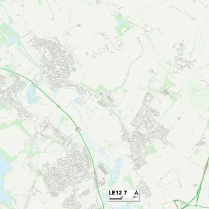
Charnwood LE11 4 Map
Postcode Sector Map of Charnwood LE11 4
Media ID 19974942
Ashby Road Ashdown Close Blackbrook Road Blenheim Close Broughton Close Browning Road Buckingham Drive Burns Road Charnwood Chatsworth Road Conway Close Cotswold Close Easby Close Hardwick Drive Hawker Close Hermitage Road Hermitage Way Howard Close Howden Close Hurstwood Road Kenilworth Avenue Kensington Avenue Kingswood Avenue Lamport Close Leighton Avenue Mildenhall Road Prestbury Road Rosehill Rudyard Close Rufford Close Sandringham Drive Schofield Road Stirling Avenue Tennyson Road Waverley Close Whitby Close Windsor Road Woburn Close Wordsworth Road
FEATURES IN THESE COLLECTIONS
> Europe
> United Kingdom
> Scotland
> Perth and Kinross
> Kinross
> Europe
> United Kingdom
> Scotland
> Stirlingshire
> Stirling
> Europe
> United Kingdom
> Wales
> Flintshire
> Broughton
> Map Marketing
> Postcode Sector Maps
> LE - Leicester
> Maps and Charts
> Related Images
> Sport
> Sports Stars
> Stirling Moss
MADE IN THE USA
Safe Shipping with 30 Day Money Back Guarantee
FREE PERSONALISATION*
We are proud to offer a range of customisation features including Personalised Captions, Color Filters and Picture Zoom Tools
SECURE PAYMENTS
We happily accept a wide range of payment options so you can pay for the things you need in the way that is most convenient for you
* Options may vary by product and licensing agreement. Zoomed Pictures can be adjusted in the Cart.