Home > Europe > United Kingdom > Wales > Powys > Newtown
Huntingdonshire PE26 1 Map

![]()
Wall Art and Photo Gifts from Map Marketing
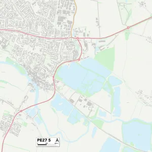
Huntingdonshire PE26 1 Map
Postcode Sector Map of Huntingdonshire PE26 1
Media ID 19977804
Abbey Fields Abbey Road Abbots Close Allen Road Biggin Lane Blenheim Road Bury Road Charles Close Cromwell Close Crown Mews Field Road Grenfell Road Hawthorn Road High Street Hollow Lane Huntingdonshire Jackson Drive Lime Road Malthouse Lane Mill Lane Millfields Milton Close New Road Newtown Road Old Station Road Oliver Close Orchard Way Park Road Princes Street School Lane Silver Street Slade Close St Marys Road Star Lane Station Gardens Station Road The Avenue The Sidings Tower Close West Avenue Westfield Road Wheatfield Drive Willow Way Wood Lane Wyatt Close Ramsey
FEATURES IN THESE COLLECTIONS
> Animals
> Insects
> Spiders
> Silver Garden
> Animals
> Mammals
> Muridae
> Little Wood Mouse
> Arts
> Portraits
> Pop art gallery
> Street art portraits
> Europe
> United Kingdom
> England
> Huntingdonshire
> Europe
> United Kingdom
> Wales
> Powys
> Newtown
> Map Marketing
> Postcode Sector Maps
> PE - Peterborough
> Maps and Charts
> Related Images
> Maps and Charts
> Star Charts
MADE IN THE USA
Safe Shipping with 30 Day Money Back Guarantee
FREE PERSONALISATION*
We are proud to offer a range of customisation features including Personalised Captions, Color Filters and Picture Zoom Tools
SECURE PAYMENTS
We happily accept a wide range of payment options so you can pay for the things you need in the way that is most convenient for you
* Options may vary by product and licensing agreement. Zoomed Pictures can be adjusted in the Cart.