Home > Europe > United Kingdom > England > London > Sights > Victoria Park
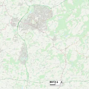
Horsham RH13 5 Map

![]()
Wall Art and Photo Gifts from Map Marketing
Horsham RH13 5 Map
Postcode Sector Map of Horsham RH13 5
Media ID 19976500
Arthur Road Barrington Road Bedford Road Bowes Close Bunting Close Burford Road Cambridge Road Clarence Road Crawford Gardens Depot Road Devonshire Road Elgin Close Elm Grove Foundry Close Foundry Lane Harwood Road Highlands Avenue Highlands Road Hornbeam Close Horsham Kennedy Road Kings Road Lanark Close Lapwing Close Livingstone Road Mills Close New Street New Town Oakhill Oakhill Road Orchard Road Oxford Road Queen Street Queensway Redwing Close South Grove Station Close Station Road Stirling Way The Poplars Victoria Street Vincent Close Waterfield Close Weald Close York Close Highworth
FEATURES IN THESE COLLECTIONS
> Animals
> Birds
> Passerines
> Chats And Flycatchers
> Nightingale
> Animals
> Mammals
> Bovidae
> Goral
> Arts
> Artists
> P
> John Pollard
> Arts
> Artists
> Q
> Queen Victoria Queen Victoria
> Arts
> Portraits
> Pop art gallery
> Street art portraits
> Europe
> United Kingdom
> England
> London
> Sights
> Victoria Park
> Europe
> United Kingdom
> Heritage Sites
> New Lanark
> Europe
> United Kingdom
> Scotland
> Highlands
> Related Images
> Europe
> United Kingdom
> Scotland
> Moray
> Elgin
> Europe
> United Kingdom
> Scotland
> Stirlingshire
> Stirling
> Map Marketing
> Postcode Sector Maps
> RH - Redhill
MADE IN THE USA
Safe Shipping with 30 Day Money Back Guarantee
FREE PERSONALISATION*
We are proud to offer a range of customisation features including Personalised Captions, Color Filters and Picture Zoom Tools
SECURE PAYMENTS
We happily accept a wide range of payment options so you can pay for the things you need in the way that is most convenient for you
* Options may vary by product and licensing agreement. Zoomed Pictures can be adjusted in the Cart.