Home > Europe > United Kingdom > Scotland > Dumfries and Galloway > Langholm
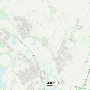
Leicester LE5 2 Map

![]()
Wall Art and Photo Gifts from Map Marketing
Leicester LE5 2 Map
Postcode Sector Map of Leicester LE5 2
Media ID 19973591
Briar Road Brook Road Colchester Road Dudley Avenue Dudley Close Fern Close Hollybush Close Kinross Avenue Leicester Nursery Road Ocean Road Somers Road St Austell Road Telford Way The Parkway Treetops Close Uppingham Road Vale Close Valentine Road Weaver Road Woodleigh Close
FEATURES IN THESE COLLECTIONS
> Animals
> Mammals
> Muridae
> Peters Mouse
> Arts
> Artists
> O
> Oceanic Oceanic
> Europe
> United Kingdom
> Scotland
> Dumfries and Galloway
> Gretna
> Europe
> United Kingdom
> Scotland
> Dumfries and Galloway
> Langholm
> Europe
> United Kingdom
> Scotland
> Perth and Kinross
> Comrie
> Europe
> United Kingdom
> Scotland
> Perth and Kinross
> Kinross
> Europe
> United Kingdom
> Scotland
> Western Isles
> Kirkwall
> Map Marketing
> Postcode Sector Maps
> LE - Leicester
> Maps and Charts
> Related Images
MADE IN THE USA
Safe Shipping with 30 Day Money Back Guarantee
FREE PERSONALISATION*
We are proud to offer a range of customisation features including Personalised Captions, Color Filters and Picture Zoom Tools
SECURE PAYMENTS
We happily accept a wide range of payment options so you can pay for the things you need in the way that is most convenient for you
* Options may vary by product and licensing agreement. Zoomed Pictures can be adjusted in the Cart.


![G. W. R Royal Albert Bridge Saltash - General Drawing [N. D. ]](/sq/229/g-w-r-royal-albert-bridge-saltash-general-12596303.jpg.webp)