Home > Europe > United Kingdom > England > Somerset > Wilton
Bournemouth BH7 6 Map

![]()
Wall Art and Photo Gifts from Map Marketing
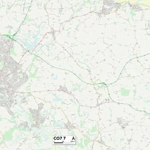
Bournemouth BH7 6 Map
Postcode Sector Map of Bournemouth BH7 6
Media ID 19965486
Bournemouth Cheriton Avenue Christchurch Road Connaught Road Gladstone Road Gloucester Road Hambledon Road Harewood Avenue Holmfield Avenue Langton Road Newlands Road North Road Petersfield Road Portman Road Roberts Road Rosebery Road Sheepwash Lane Somerset Road Tamworth Road Waltham Road Warwick Road Wickham Road Wilton Road Wolverton Road York Place Harewood Place
FEATURES IN THESE COLLECTIONS
> Europe
> United Kingdom
> England
> Somerset
> Related Images
> Europe
> United Kingdom
> England
> Somerset
> Wilton
> Map Marketing
> Postcode Sector Maps
> BH - Bournemouth
> Maps and Charts
> Related Images
MADE IN THE USA
Safe Shipping with 30 Day Money Back Guarantee
FREE PERSONALISATION*
We are proud to offer a range of customisation features including Personalised Captions, Color Filters and Picture Zoom Tools
SECURE PAYMENTS
We happily accept a wide range of payment options so you can pay for the things you need in the way that is most convenient for you
* Options may vary by product and licensing agreement. Zoomed Pictures can be adjusted in the Cart.