Home > Europe > United Kingdom > England > London > Towns > Addington
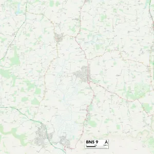
Tonbridge and Malling ME19 5 Map

![]()
Wall Art and Photo Gifts from Map Marketing
Tonbridge and Malling ME19 5 Map
Postcode Sector Map of Tonbridge and Malling ME19 5
Media ID 19974716
Ashton Way Brickfields Broadoak Brooks Drive Castle Way Chapel Close Chapel Street Church Lane Church Road Cooper Lane Danes Close Dobson Close East Street Evergreen Close Ford Lane Grange Close Green Lane Hawthorne Grove Hayes Lane Hayfield Hodges Close London Road Millbrook Old Barn Road Old School Lane Park Farm Road Park Road Pilgrims Way Price Close Quarry Road Rose Avenue Rowan Street Sandy Lane School Lane Taylors Lane The Chestnuts The Close The Croft The Links The Mead The Paddocks The Street The Willows Tonbridge And Malling Tower Hill Woodgate Road Woodlea Addington Birling Downsview Leybourne Offham Roundhay Wheatfield
FEATURES IN THESE COLLECTIONS
> Animals
> Mammals
> Muridae
> Heath Mouse
> Animals
> Mammals
> Muridae
> Water Mouse
> Architecture
> Towers
> Castles
> Architecture
> Towers
> Churches
> Arts
> Portraits
> Pop art gallery
> Street art portraits
> Europe
> United Kingdom
> England
> London
> Related Images
> Europe
> United Kingdom
> England
> London
> Sights
> Brick Lane
> Europe
> United Kingdom
> England
> London
> Sights
> Green Park
> Europe
> United Kingdom
> England
> London
> Towns
> Addington
> Europe
> United Kingdom
> England
> London
> Towns
> Grange Park
> Map Marketing
> Postcode Sector Maps
> ME - Rochester
MADE IN THE USA
Safe Shipping with 30 Day Money Back Guarantee
FREE PERSONALISATION*
We are proud to offer a range of customisation features including Personalised Captions, Color Filters and Picture Zoom Tools
SECURE PAYMENTS
We happily accept a wide range of payment options so you can pay for the things you need in the way that is most convenient for you
* Options may vary by product and licensing agreement. Zoomed Pictures can be adjusted in the Cart.