Home > Europe > United Kingdom > England > Maps
Photo Mug : Map / Manchester 1878


![]()
Home Decor from Mary Evans Picture Library
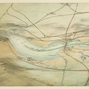
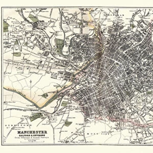
Map / Manchester 1878
Map of Manchester and its environs
Mary Evans Picture Library makes available wonderful images created for people to enjoy over the centuries
Media ID 608785
© Mary Evans Picture Library 2015 - https://copyrighthub.org/s0/hub1/creation/maryevans/MaryEvansPictureID/10113946
Photo Mug (11 oz)
Introducing the Media Storehouse Photo Mug, a perfect blend of functionality and personalization. This mug is not just an ordinary drinkware, it's a daily reminder of the rich history of Manchester. Featuring an exquisite image of "Map / Manchester 1878" by Mary Evans Picture Library from Mary Evans Prints Online, this mug showcases intricate details of the map, transporting you back in time. Whether you're an avid history buff or simply appreciate the beauty of vintage maps, this mug is a must-have addition to your collection. Each mug is printed with high-quality, long-lasting ink, ensuring the image remains vibrant and clear. Enjoy your favorite beverage while immersing yourself in the past. Bring a piece of Manchester's history with you wherever you go.
A personalized photo mug blends sentimentality with functionality, making an ideal gift for cherished loved ones, close friends, or valued colleagues. Preview may show both sides of the same mug.
Elevate your coffee or tea experience with our premium white ceramic mug. Its wide, comfortable handle makes drinking easy, and you can rely on it to be both microwave and dishwasher safe. Sold in single units, preview may show both sides of the same mug so you can see how the picture wraps around.
Mug Size is 8cm high x 9.5cm diameter (3.1" x 3.7")
These are individually made so all sizes are approximate
FEATURES IN THESE COLLECTIONS
> Europe
> United Kingdom
> England
> Maps
> Maps and Charts
> Early Maps
EDITORS COMMENTS
This stunning print of a map of Manchester from 1878 offers a fascinating glimpse into the history and development of this iconic city in England. The intricate details captured in this map provide a snapshot of Manchester and its environs during a pivotal moment in time, showcasing the layout of streets, landmarks, and neighborhoods as they existed over 140 years ago.
As we study this historical map, we can see how the city has evolved and grown over the decades, with changes in infrastructure, urban planning, and population density all reflected in the cartographic representation. From bustling city centers to sprawling suburbs, every corner of Manchester is meticulously documented on this vintage map.
The rich history embedded within these lines and symbols invites us to explore the past and imagine what life was like for residents of Manchester in the late 19th century. It serves as a reminder of how far the city has come since then while also highlighting its enduring legacy as an industrial powerhouse with a vibrant cultural heritage.
Whether you're a history buff, geography enthusiast or simply curious about Manchester's roots, this print is sure to spark your imagination and deepen your appreciation for one of England's most dynamic cities.
MADE IN THE USA
Safe Shipping with 30 Day Money Back Guarantee
FREE PERSONALISATION*
We are proud to offer a range of customisation features including Personalised Captions, Color Filters and Picture Zoom Tools
SECURE PAYMENTS
We happily accept a wide range of payment options so you can pay for the things you need in the way that is most convenient for you
* Options may vary by product and licensing agreement. Zoomed Pictures can be adjusted in the Cart.