Home > Europe > United Kingdom > England > Maps
Jigsaw Puzzle : MAP / LONDON 1878


![]()
Jigsaw Puzzles from Mary Evans Picture Library
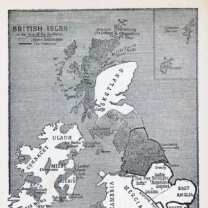
MAP / LONDON 1878
Map of London and its suburbs
Mary Evans Picture Library makes available wonderful images created for people to enjoy over the centuries
Media ID 608786
© Mary Evans Picture Library 2015 - https://copyrighthub.org/s0/hub1/creation/maryevans/MaryEvansPictureID/10113947
Jigsaw Puzzle (252 Pieces)
Discover the captivating history of London in 1878 with our exquisite jigsaw puzzle from Media Storehouse and Mary Evans Picture Library. This intricately detailed puzzle features an authentic map of London and its suburbs, revealing the city's rich architectural heritage and the bustling growth it experienced during that era. Immerse yourself in the past as you piece together this captivating jigsaw puzzle, perfect for puzzle enthusiasts, history buffs, and anyone seeking a fun and engaging activity. Experience the thrill of discovery as you reveal the intricacies of the map, uncovering the hidden gems and landmarks that shaped London over a century ago. Bring history to life in your home with this stunning jigsaw puzzle from Media Storehouse.
Made in the USA, 252-piece puzzles are printed on photographic paper. Excluding the outer edge, all of the pieces are the same shape with the completed puzzle measuring 10" x 14" (25.4 x 35.5 cm). Split into individual pieces, puzzles are supplied in a black presentation box, sized to fit most mailboxes, with a professionally printed photo on top for reference (box dimensions 5 5/8" x 7 5/8" x 1 1/5")
Jigsaw Puzzles are an ideal gift for any occasion
Estimated Product Size is 37.2cm x 29.2cm (14.6" x 11.5")
These are individually made so all sizes are approximate
Artwork printed orientated as per the preview above, with landscape (horizontal) or portrait (vertical) orientation to match the source image.
FEATURES IN THESE COLLECTIONS
> Europe
> United Kingdom
> England
> Maps
> Maps and Charts
> Early Maps
EDITORS COMMENTS
This stunning print of a Map of London and its suburbs from 1878 offers a fascinating glimpse into the history and development of England's capital city. The intricate details captured in this map provide a snapshot of London during a time when it was rapidly expanding and evolving.
As we study the various neighborhoods, streets, and landmarks depicted on this historical map, we can't help but marvel at how much has changed over the years. From bustling city centers to quaint suburban villages, each area tells its own unique story about life in Victorian-era London.
The craftsmanship and attention to detail that went into creating this map are truly remarkable. Every street corner, park, and building is meticulously illustrated, giving us an insight into what life was like for Londoners more than a century ago.
Whether you're a history buff or simply appreciate beautiful works of art, this Map of London from 1878 is sure to captivate your imagination. It serves as a reminder of how far London has come since then while also preserving the charm and character that have made it one of the world's most iconic cities.
Mary Evans Picture Library has once again curated an exceptional piece that not only educates but also inspires us to explore the rich tapestry of London's past.
MADE IN THE USA
Safe Shipping with 30 Day Money Back Guarantee
FREE PERSONALISATION*
We are proud to offer a range of customisation features including Personalised Captions, Color Filters and Picture Zoom Tools
SECURE PAYMENTS
We happily accept a wide range of payment options so you can pay for the things you need in the way that is most convenient for you
* Options may vary by product and licensing agreement. Zoomed Pictures can be adjusted in the Cart.