Home > Europe > Iceland > Maps
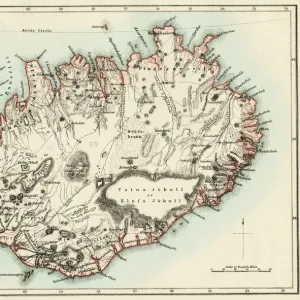
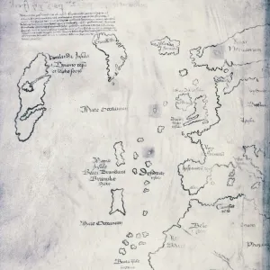
Canvas Print : Map / Europe / Iceland 18C


![]()
Canvas Prints from Mary Evans Picture Library
Map / Europe / Iceland 18C
Date: early 18th century
Mary Evans Picture Library makes available wonderful images created for people to enjoy over the centuries
Media ID 571502
© Mary Evans Picture Library 2015 - https://copyrighthub.org/s0/hub1/creation/maryevans/MaryEvansPictureID/10003760
20"x16" (51x41cm) Canvas Print
Introducing the exquisite "Map / Europe / Iceland 18C" canvas print from our Media Storehouse collection, brought to you in partnership with Mary Evans Picture Library from Mary Evans Prints Online. This stunning work of art transports you back to the early 18th century with its intricate and beautifully detailed map of Europe, highlighting the captivating island of Iceland. Each canvas print is meticulously crafted, bringing the rich history and intrigue of this vintage map to your home or office. The high-quality canvas material enhances the vibrant colors and fine lines, creating a truly captivating piece of art that is sure to impress. Elevate your space with a touch of history and the timeless beauty of this exceptional Map of Europe canvas print.
Delivered stretched and ready to hang our premium quality canvas prints are made from a polyester/cotton blend canvas and stretched over a 1.25" (32mm) kiln dried knot free wood stretcher bar. Packaged in a plastic bag and secured to a cardboard insert for safe transit.
Canvas Prints add colour, depth and texture to any space. Professionally Stretched Canvas over a hidden Wooden Box Frame and Ready to Hang
Estimated Product Size is 50.8cm x 40.6cm (20" x 16")
These are individually made so all sizes are approximate
Artwork printed orientated as per the preview above, with landscape (horizontal) orientation to match the source image.
FEATURES IN THESE COLLECTIONS
> Europe
> Iceland
> Related Images
> Maps and Charts
> Early Maps
EDITORS COMMENTS
This print of a historical map of Europe, specifically focusing on Iceland in the early 18th century, offers a fascinating glimpse into the past. The intricate details and delicate craftsmanship of this map showcase the cartographer's skill and dedication to accurately representing the geography of this region during that time period.
As we study this map, we are transported back to a time when exploration and discovery were at the forefront of society. The names of towns, rivers, and mountains are carefully labeled, providing valuable insight into how people navigated and understood their world centuries ago.
Iceland, with its rugged terrain and unique cultural heritage, is prominently featured on this map, reminding us of its importance in European history. From Reykjavik to Akureyri, each place is meticulously depicted with precision and care.
This print from Mary Evans Picture Library serves as a reminder of the rich history that has shaped our world today. It invites us to explore the past through cartography and appreciate the artistry involved in creating such detailed maps. Whether you are a history buff or simply intrigued by old-world charm, this map is sure to captivate your imagination and inspire further exploration into Europe's fascinating past.
MADE IN THE USA
Safe Shipping with 30 Day Money Back Guarantee
FREE PERSONALISATION*
We are proud to offer a range of customisation features including Personalised Captions, Color Filters and Picture Zoom Tools
SECURE PAYMENTS
We happily accept a wide range of payment options so you can pay for the things you need in the way that is most convenient for you
* Options may vary by product and licensing agreement. Zoomed Pictures can be adjusted in the Cart.