Home > Maps and Charts > Early Maps
Jigsaw Puzzle : Map / Channel Islands 18C


![]()
Jigsaw Puzzles from Mary Evans Picture Library
Map / Channel Islands 18C
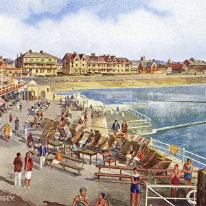
Map of Jersey, Guernsey, Alderney, Sark and the Scilly Isles
Mary Evans Picture Library makes available wonderful images created for people to enjoy over the centuries
Media ID 607569
© Mary Evans Picture Library 2015 - https://copyrighthub.org/s0/hub1/creation/maryevans/MaryEvansPictureID/10059488
Alderney Channel Guernsey Isles Jersey Maps S Ark Scilly
Jigsaw Puzzle (252 Pieces)
Discover the captivating history and intricate beauty of the Channel Islands with our latest addition to the Media Storehouse Jigsaw Puzzle collection. Featuring an exquisite map titled "Map / Channel Islands 18C" from Mary Evans Picture Library, this puzzle invites you on a journey back in time. Explore the intricate details of the maps of Jersey, Guernsey, Alderney, Sark, and the Scilly Isles as they appeared in the 18th century. Assembling this puzzle is not just a pastime but an opportunity to learn and appreciate the rich history of these fascinating islands. Piece together the past and uncover the timeless charm of the Channel Islands with Media Storehouse.
Made in the USA, 252-piece puzzles measure 11" x 14" (27.9 x 35.5 cm). Every puzzle is meticulously printed on glossy photo paper, which has a strong 1.33 mm thickness. Delivered in a black storage cardboard box, these puzzles are both stylish and practical. (Note: puzzles contain small parts and are not suitable for children under 3 years of age.)
Jigsaw Puzzles are an ideal gift for any occasion
Estimated Product Size is 35.6cm x 28cm (14" x 11")
These are individually made so all sizes are approximate
Artwork printed orientated as per the preview above, with landscape (horizontal) orientation to match the source image.
EDITORS COMMENTS
This stunning historical print showcases a detailed map of the Channel Islands in the 18th century, including Jersey, Guernsey, Alderney, Sark and the Scilly Isles. The intricate details and vibrant colors bring to life the rich history and significance of these islands in centuries past.
Each island is clearly labeled on the map, allowing viewers to imagine what life was like in this region during this time period. From bustling ports to quaint villages, this map provides a glimpse into the diverse landscapes and communities that existed on these islands hundreds of years ago.
The meticulous craftsmanship of this map is evident in every line and symbol, reflecting the expertise and dedication of cartographers from centuries past. It serves as a reminder of how maps have been essential tools for exploration, navigation, and understanding our world throughout history.
Whether you have a personal connection to these islands or simply appreciate historical artifacts, this print is sure to captivate your imagination and spark curiosity about the stories hidden within its borders. Display it proudly in your home or office as a conversation piece that will transport you back in time to an era filled with discovery and adventure.
MADE IN THE USA
Safe Shipping with 30 Day Money Back Guarantee
FREE PERSONALISATION*
We are proud to offer a range of customisation features including Personalised Captions, Color Filters and Picture Zoom Tools
SECURE PAYMENTS
We happily accept a wide range of payment options so you can pay for the things you need in the way that is most convenient for you
* Options may vary by product and licensing agreement. Zoomed Pictures can be adjusted in the Cart.