Photographic Print : Map at the Berlin Air Safety Centre, during the Berlin Airli
![]()

Photo Prints from Mary Evans Picture Library
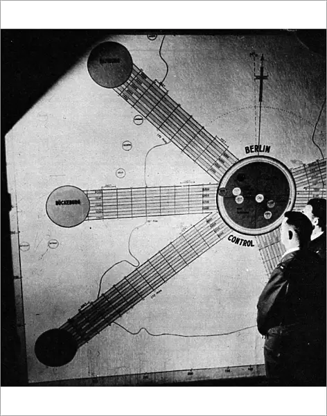
Map at the Berlin Air Safety Centre, during the Berlin Airli
Photograph showing a large wall map of Berlin and its air corridors, in the Berlin Air Safety Centre, during the airlift of 1948. This centre was used to co-ordinate air movements between the four powers occupying Berlin (USA, Great Britain, USSR, France) to ensure to efficient and safe transit of airplanes. Between April 1948 and May 1949 Stalin, leader of the USSR, imposed a land blockade on supplies from Western Europe to West Berlin. In response the British and American governments organised an enormous airlift to supply food and other essentials to the 2.5 million inhabitants of West Berlin. After a year Stalin conceded defeat and lifted the land blockade
Mary Evans Picture Library makes available wonderful images created for people to enjoy over the centuries
Media ID 4391663
© Mary Evans Picture Library 2015 - https://copyrighthub.org/s0/hub1/creation/maryevans/MaryEvansPictureID/10219884
1948 1949 Air Lift Air Planes Berlin Blockade Conceded Corridors Defeat Efficient Enormous Ensure Essentials Governments Imposed Inhabitants Lifted Million Movements Occupying Organised Powers Response Safe Safety Stalin Supplies Supply Transit Uss R Year
14"x11" Photo Print
Introducing the captivating "Map at the Berlin Air Safety Centre, during the Berlin Airlift" print from our Media Storehouse collection. This evocative photograph, sourced from Mary Evans Prints Online, transports you back in time to the historic Berlin Air Safety Centre during the pivotal Berlin Airlift of 1948. The image showcases a large, intricate wall map of Berlin and its air corridors, meticulously plotted with precision and detail. A must-have for history enthusiasts, aviation aficionados, or anyone who appreciates the power of visual storytelling, this print adds depth and character to any space. Bring a piece of history into your home or office with the "Map at the Berlin Air Safety Centre, during the Berlin Airlift" print from Media Storehouse.
Photo prints are produced on Kodak professional photo paper resulting in timeless and breath-taking prints which are also ideal for framing. The colors produced are rich and vivid, with accurate blacks and pristine whites, resulting in prints that are truly timeless and magnificent. Whether you're looking to display your prints in your home, office, or gallery, our range of photographic prints are sure to impress. Dimensions refers to the size of the paper in inches.
Our Photo Prints are in a large range of sizes and are printed on Archival Quality Paper for excellent colour reproduction and longevity. They are ideal for framing (our Framed Prints use these) at a reasonable cost. Alternatives include cheaper Poster Prints and higher quality Fine Art Paper, the choice of which is largely dependant on your budget.
Estimated Product Size is 27.9cm x 35.5cm (11" x 14")
These are individually made so all sizes are approximate
Artwork printed orientated as per the preview above, with portrait (vertical) orientation to match the source image.
EDITORS COMMENTS
This historic photograph captures the Map Wall at the Berlin Air Safety Centre during the Berlin Airlift of 1948. The Centre played a crucial role in coordinating air movements between the four occupying powers of Berlin - the United States, Great Britain, France, and the Soviet Union - to ensure the efficient and safe transit of airplanes carrying essential supplies to the beleaguered inhabitants of West Berlin. In April 1948, Stalin, the Soviet Union's leader, imposed a land blockade on all imports to West Berlin, cutting off its access to food and other essentials. In response, the British and American governments launched an enormous airlift operation to supply the 2.5 million inhabitants of West Berlin with the necessities they required to survive. The Map Wall at the Berlin Air Safety Centre was instrumental in the success of this operation. The large-scale map, adorned with intricate air corridors and markings, allowed the various powers to communicate effectively and coordinate their efforts to keep the airlift running smoothly. The Centre's role in ensuring the safe and efficient transit of airplanes was crucial in the face of the challenging conditions, as the skies over Berlin were congested with constant air traffic. After a year of intense airlift operations, Stalin finally conceded defeat and lifted the land blockade in May 1949. This photograph serves as a poignant reminder of the determination and cooperation required to overcome such a significant challenge in the aftermath of World War II.
MADE IN THE USA
Safe Shipping with 30 Day Money Back Guarantee
FREE PERSONALISATION*
We are proud to offer a range of customisation features including Personalised Captions, Color Filters and Picture Zoom Tools
FREE COLORIZATION SERVICE
You can choose advanced AI Colorization for this picture at no extra charge!
SECURE PAYMENTS
We happily accept a wide range of payment options so you can pay for the things you need in the way that is most convenient for you
* Options may vary by product and licensing agreement. Zoomed Pictures can be adjusted in the Cart.


