Home > Maps and Charts > Early Maps
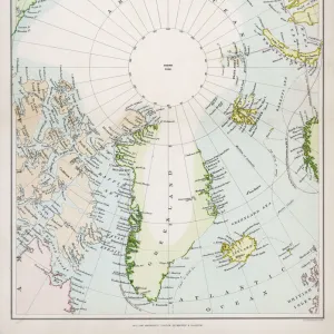
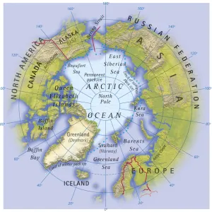
Photographic Print : Map / Arctic Circle 1895


Photo Prints from Mary Evans Picture Library
Map / Arctic Circle 1895
Map of the Arctic Circle and surrounding areas
Mary Evans Picture Library makes available wonderful images created for people to enjoy over the centuries
Media ID 608851
© Mary Evans Picture Library 2015 - https://copyrighthub.org/s0/hub1/creation/maryevans/MaryEvansPictureID/10114181
Arctic Circle Maps Surrounding 1895
14"x11" Photo Print
Discover the captivating beauty of the Arctic Circle with our exquisite photographic print from Mary Evans Picture Library. This vintage map, dated 1895, transports you to a time when exploration and discovery were at the forefront of human endeavor. The intricate details of the Arctic Circle and its surrounding areas are brought to life in this stunning print, making it an essential addition to any home or office. Printed on high-quality archival paper, this photographic print is not only a beautiful piece of art but also a testament to the rich history of cartography. Bring a touch of the past into your present with the Media Storehouse range of Photographic Prints.
Photo prints are produced on Kodak professional photo paper resulting in timeless and breath-taking prints which are also ideal for framing. The colors produced are rich and vivid, with accurate blacks and pristine whites, resulting in prints that are truly timeless and magnificent. Whether you're looking to display your prints in your home, office, or gallery, our range of photographic prints are sure to impress. Dimensions refers to the size of the paper in inches.
Our Photo Prints are in a large range of sizes and are printed on Archival Quality Paper for excellent colour reproduction and longevity. They are ideal for framing (our Framed Prints use these) at a reasonable cost. Alternatives include cheaper Poster Prints and higher quality Fine Art Paper, the choice of which is largely dependant on your budget.
Estimated Product Size is 35.5cm x 27.9cm (14" x 11")
These are individually made so all sizes are approximate
Artwork printed orientated as per the preview above, with landscape (horizontal) or portrait (vertical) orientation to match the source image.
FEATURES IN THESE COLLECTIONS
> Maps and Charts
> Early Maps
> Popular Themes
> Maps and Charts
EDITORS COMMENTS
This stunning print captures a piece of history with the Map of the Arctic Circle from 1895. The intricate details and design of this map provide a fascinating glimpse into the past, showcasing the geographical layout of the Arctic Circle and its surrounding areas during that time period.
The historical significance of this map is undeniable, as it offers valuable insights into how explorers navigated through these icy waters over a century ago. From the rugged terrain to the icy waters, every element on this map tells a story of adventure and discovery in one of Earth's most remote regions.
As we study this map closely, we can't help but marvel at the dedication and bravery of those who ventured into these uncharted territories in search of new lands and resources. The precision and accuracy with which this map was created are truly remarkable, highlighting both scientific knowledge and artistic skill.
Whether you're a history buff or simply appreciate beautiful cartography, this Map of the Arctic Circle from 1895 is sure to captivate your imagination. It serves as a reminder of our planet's vastness and diversity, urging us to explore beyond our comfort zones and embrace new horizons just waiting to be discovered.
MADE IN THE USA
Safe Shipping with 30 Day Money Back Guarantee
FREE PERSONALISATION*
We are proud to offer a range of customisation features including Personalised Captions, Color Filters and Picture Zoom Tools
SECURE PAYMENTS
We happily accept a wide range of payment options so you can pay for the things you need in the way that is most convenient for you
* Options may vary by product and licensing agreement. Zoomed Pictures can be adjusted in the Cart.