Home > Africa > Algeria > Constantine
Photographic Print : Map / Africa / Algeria C1850


![]()
Photo Prints from Mary Evans Picture Library
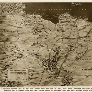
Map / Africa / Algeria C1850
Algeria under French rule, divided into three provinces of Oran, Algiers and Constantine Date: circa 1850
Mary Evans Picture Library makes available wonderful images created for people to enjoy over the centuries
Media ID 7133789
© Mary Evans Picture Library 2015 - https://copyrighthub.org/s0/hub1/creation/maryevans/MaryEvansPictureID/10046918
1850 Algeria Algiers C1850 Constantine Divided Maps Oran Provinces Rule
14"x11" Photo Print
Discover the rich history of Algeria with our exquisite Media Storehouse Photographic Print of 'Map / Africa / Algeria C1850'. This captivating image, sourced from Mary Evans Prints Online, provides a glimpse into Algeria during the French rule, expertly divided into the provinces of Oran, Algiers, and Constantine. The intricate details of this rights-managed map, believed to date back to circa 1850, transport you back in time and offer a unique perspective on the historical landscape. Perfect for adding depth to your home or office decor, this high-quality photographic print is a must-have for history enthusiasts, educators, or anyone with a passion for the world's diverse cultures.
Photo prints are produced on Kodak professional photo paper resulting in timeless and breath-taking prints which are also ideal for framing. The colors produced are rich and vivid, with accurate blacks and pristine whites, resulting in prints that are truly timeless and magnificent. Whether you're looking to display your prints in your home, office, or gallery, our range of photographic prints are sure to impress. Dimensions refers to the size of the paper in inches.
Our Photo Prints are in a large range of sizes and are printed on Archival Quality Paper for excellent colour reproduction and longevity. They are ideal for framing (our Framed Prints use these) at a reasonable cost. Alternatives include cheaper Poster Prints and higher quality Fine Art Paper, the choice of which is largely dependant on your budget.
Estimated Product Size is 35.5cm x 27.9cm (14" x 11")
These are individually made so all sizes are approximate
Artwork printed orientated as per the preview above, with landscape (horizontal) or portrait (vertical) orientation to match the source image.
FEATURES IN THESE COLLECTIONS
> Africa
> Algeria
> Constantine
> Africa
> Algeria
> Related Images
EDITORS COMMENTS
This map print, dated circa 1850, offers a glimpse into the historical division of Algeria under French rule. At the time, Algeria was not yet an official French colony but was instead governed as three distinct provinces: Oran, Algiers, and Constantine. The map illustrates the geographical boundaries of each province, with the Mediterranean Sea to the north, the Sahara Desert to the south, and the Atlas Mountains to the southwest. The French influence is evident in the map's title, which is written in both French and Latin, reflecting the European perspective of the region. The intricate detailing of the map, including the depiction of major cities, rivers, and mountains, showcases the extensive exploration and cartographic knowledge of the time. The map serves as a poignant reminder of the complex history of Algeria and its relationship with France. The French conquest of Algeria began in 1830 and lasted until 1962, making it one of the longest colonial occupations in history. The division of Algeria into provinces was a strategic move to facilitate the administration and control of the vast territory. This map print is an essential addition to any collection of historical maps or those interested in the history of Africa, colonialism, or cartography. Its intricate detailing and historical significance make it a fascinating and educational piece that can transport us back in time to an era of exploration and discovery.
MADE IN THE USA
Safe Shipping with 30 Day Money Back Guarantee
FREE PERSONALISATION*
We are proud to offer a range of customisation features including Personalised Captions, Color Filters and Picture Zoom Tools
SECURE PAYMENTS
We happily accept a wide range of payment options so you can pay for the things you need in the way that is most convenient for you
* Options may vary by product and licensing agreement. Zoomed Pictures can be adjusted in the Cart.