Home > Europe > United Kingdom > England > London > Sights > Trafalgar Square
Canvas Print : London Map 1756


![]()
Canvas Prints from Mary Evans Picture Library
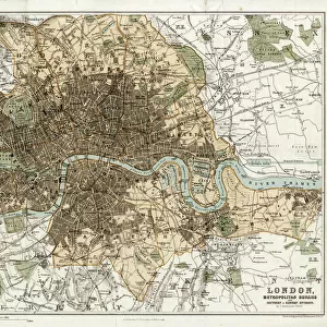
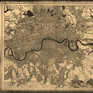
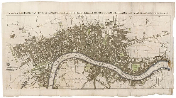
London Map 1756
London still surrounded by fields, with Tyburn (note the gallows) and Buckingham House on the outskirts. Trafalgar Square doesn t exist, and Mayfair is still undeveloped
Mary Evans Picture Library makes available wonderful images created for people to enjoy over the centuries
Media ID 587889
© Mary Evans Picture Library 2015 - https://copyrighthub.org/s0/hub1/creation/maryevans/MaryEvansPictureID/10187933
1756 Buckingham Exist Fields Gallows Maps Mayfair Note Outskirts Plans Surrounded Trafalgar Tyburn Undeveloped
12"x9" (30x23cm) Canvas Print
Discover history like never before with Media Storehouse's Canvas Prints featuring the captivating "London Map 1756" from Mary Evans Picture Library. Travel back in time to an era where London was still surrounded by fields, with Tyburn gallows and Buckingham House on its outskirts. Witness the city's evolution as Trafalgar Square and the developed Mayfair are yet to emerge. Bring this intriguing piece of history into your home and add a touch of timeless charm to your decor. Our Canvas Prints are made using premium materials and printing techniques to ensure vibrant colors and sharp details, making each print a unique work of art. Order yours today and start your journey through history.
Delivered stretched and ready to hang our premium quality canvas prints are made from a polyester/cotton blend canvas and stretched over a 1.25" (32mm) kiln dried knot free wood stretcher bar. Packaged in a plastic bag and secured to a cardboard insert for safe transit.
Canvas Prints add colour, depth and texture to any space. Professionally Stretched Canvas over a hidden Wooden Box Frame and Ready to Hang
Estimated Product Size is 30.5cm x 22.9cm (12" x 9")
These are individually made so all sizes are approximate
Artwork printed orientated as per the preview above, with landscape (horizontal) orientation to match the source image.
FEATURES IN THESE COLLECTIONS
> Europe
> United Kingdom
> England
> London
> Sights
> Trafalgar Square
> Europe
> United Kingdom
> England
> Maps
> Maps and Charts
> Early Maps
EDITORS COMMENTS
This fascinating print of the "London Map 1756" takes us back in time to a London that is almost unrecognizable from the bustling metropolis we know today. In this map, London is still surrounded by vast fields, with only Tyburn (note the gallows) and Buckingham House on the outskirts of the city. Trafalgar Square has yet to be built, and Mayfair remains undeveloped.
The intricate details of this historical map provide a glimpse into what life was like in 18th century England. The plans and layouts depicted here offer a unique perspective on how urban development has transformed over the centuries.
As you study this map closely, you can't help but marvel at how much London has evolved since 1756. The contrast between then and now is striking, highlighting just how much history is woven into every corner of this vibrant city.
Whether you're a history buff or simply appreciate fine art, this print from Mary Evans Picture Library is sure to captivate your imagination and spark curiosity about London's rich past. It serves as a reminder that even in an ever-changing world, traces of our heritage are always waiting to be discovered.
MADE IN THE USA
Safe Shipping with 30 Day Money Back Guarantee
FREE PERSONALISATION*
We are proud to offer a range of customisation features including Personalised Captions, Color Filters and Picture Zoom Tools
SECURE PAYMENTS
We happily accept a wide range of payment options so you can pay for the things you need in the way that is most convenient for you
* Options may vary by product and licensing agreement. Zoomed Pictures can be adjusted in the Cart.