Home > Europe > United Kingdom > England > London > Sights > Trafalgar Square
Framed Print : London Map 1756


![]()
Framed Photos from Mary Evans Picture Library
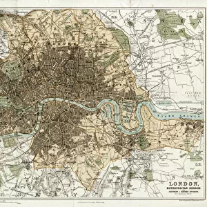
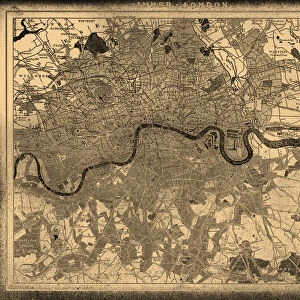
London Map 1756
London still surrounded by fields, with Tyburn (note the gallows) and Buckingham House on the outskirts. Trafalgar Square doesn t exist, and Mayfair is still undeveloped
Mary Evans Picture Library makes available wonderful images created for people to enjoy over the centuries
Media ID 587889
© Mary Evans Picture Library 2015 - https://copyrighthub.org/s0/hub1/creation/maryevans/MaryEvansPictureID/10187933
1756 Buckingham Exist Fields Gallows Maps Mayfair Note Outskirts Plans Surrounded Trafalgar Tyburn Undeveloped
22"x18" Modern Frame
Discover history like never before with Media Storehouse's Framed Prints featuring the captivating "London Map 1756" from Mary Evans Picture Library. Travel back in time with this intricately detailed map, showcasing London as it was over 250 years ago. Witness the city's transformation as you see London still surrounded by fields, with Tyburn gallows and Buckingham House situated on its outskirts. Trafalgar Square doesn't exist yet, and Mayfair remains undeveloped. This beautifully framed print is not only a stunning addition to your home or office decor, but it is also a fascinating glimpse into London's rich history. Bring the past to life with Media Storehouse's Framed Prints.
20x16 Print in an MDF Wooden Frame with 180 gsm Satin Finish Paper. Glazed using shatter proof thin plexiglass. Frame thickness is 1 inch and depth 0.75 inch. Fluted cardboard backing held with clips. Supplied ready to hang with sawtooth hanger and rubber bumpers. Spot clean with a damp cloth. Packaged foam wrapped in a card.
Contemporary Framed and Mounted Prints - Professionally Made and Ready to Hang
Estimated Image Size (if not cropped) is 50.8cm x 45.7cm (20" x 18")
Estimated Product Size is 55.9cm x 45.7cm (22" x 18")
These are individually made so all sizes are approximate
Artwork printed orientated as per the preview above, with landscape (horizontal) orientation to match the source image.
FEATURES IN THESE COLLECTIONS
> Europe
> United Kingdom
> England
> London
> Sights
> Trafalgar Square
> Europe
> United Kingdom
> England
> Maps
> Maps and Charts
> Early Maps
EDITORS COMMENTS
This fascinating print of the "London Map 1756" takes us back in time to a London that is almost unrecognizable from the bustling metropolis we know today. In this map, London is still surrounded by vast fields, with only Tyburn (note the gallows) and Buckingham House on the outskirts of the city. Trafalgar Square has yet to be built, and Mayfair remains undeveloped.
The intricate details of this historical map provide a glimpse into what life was like in 18th century England. The plans and layouts depicted here offer a unique perspective on how urban development has transformed over the centuries.
As you study this map closely, you can't help but marvel at how much London has evolved since 1756. The contrast between then and now is striking, highlighting just how much history is woven into every corner of this vibrant city.
Whether you're a history buff or simply appreciate fine art, this print from Mary Evans Picture Library is sure to captivate your imagination and spark curiosity about London's rich past. It serves as a reminder that even in an ever-changing world, traces of our heritage are always waiting to be discovered.
MADE IN THE USA
Safe Shipping with 30 Day Money Back Guarantee
FREE PERSONALISATION*
We are proud to offer a range of customisation features including Personalised Captions, Color Filters and Picture Zoom Tools
SECURE PAYMENTS
We happily accept a wide range of payment options so you can pay for the things you need in the way that is most convenient for you
* Options may vary by product and licensing agreement. Zoomed Pictures can be adjusted in the Cart.