Home > Arts > Artists > K > Johannes van Keulen
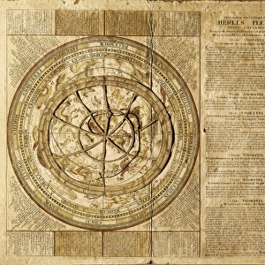
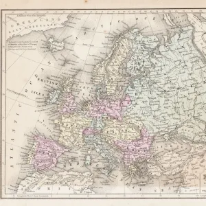
Sea chart of the Danish Islands, part of the coast of Sweden and Germany, Jan Luyken

![]()
Wall Art and Photo Gifts from Liszt Collection
Sea chart of the Danish Islands, part of the coast of Sweden and Germany, Jan Luyken
Sea chart of the Danish Islands, part of the coast of Sweden and Germany, Jan Luyken, Johannes van Keulen I, unknown, 1681-1799
Liszt Collection of nineteenth-century engravings and images to browse and enjoy
Media ID 12716343
© Quint Lox Limited
1681 1799 Address Boar Cartouche Chasing Coast Compass Compasses Danish Dogs French Miles Hunter Hunters Hunting Dogs Islands Jan Luyken Johannes Van Keulen Look North Portion Roses Sea Chart Spanish Sweden Wild Boar Chart Comrade
FEATURES IN THESE COLLECTIONS
> Animals
> Mammals
> Suidae
> Wild Boar
> Arts
> Artists
> K
> Johannes van Keulen
> Arts
> Artists
> L
> Jan Luyken
> Maps and Charts
> World
EDITORS COMMENTS
This print showcases a remarkable sea chart of the Danish Islands, part of the coast of Sweden and Germany. Created by Jan Luyken and Johannes van Keulen I between 1681 and 1799, this map is a true testament to their mastery in cartography. The intricate details on this piece reveal an extraordinary level of skill and precision. In the foreground, we see hunters accompanied by their loyal hunting dogs, ready for adventure. They sit attentively as they examine the sea chart with great curiosity. Their comrade peers over their shoulders, engrossed in deciphering the geographical features depicted on this fascinating map. As our eyes wander across the chart, we notice compasses pointing northward and delicate cartouches embellishing important addresses along the coastline. This comprehensive representation includes not only Danish islands but also portions of Sweden and Germany. Meanwhile, in another corner of this artwork, we witness hunting dogs passionately chasing after a wild boar – a thrilling scene that adds an element of action to this otherwise scholarly composition. The inclusion of various measurements such as German, Spanish, English miles further emphasizes its practicality for navigators exploring these waters during that era. Overall, Quint Lox's expertly captured photograph allows us to appreciate both the artistry and historical significance behind Jan Luyken's masterpiece while transporting us back to an age when maps were essential tools for exploration.
MADE IN THE USA
Safe Shipping with 30 Day Money Back Guarantee
FREE PERSONALISATION*
We are proud to offer a range of customisation features including Personalised Captions, Color Filters and Picture Zoom Tools
SECURE PAYMENTS
We happily accept a wide range of payment options so you can pay for the things you need in the way that is most convenient for you
* Options may vary by product and licensing agreement. Zoomed Pictures can be adjusted in the Cart.